IMAGES TAKEN NEAR TO
/Millfields Way, BRIDGNORTH, WV16 6AJ
Introduction
This page details the photographs taken nearby to /Millfields Way, WV16 6AJ by members of the Geograph project.
The Geograph project started in 2005 with the aim of publishing, organising and preserving representative images for every square kilometre of Great Britain, Ireland and the Isle of Man.

There are currently over 7.5m images from over14,400 individuals and you can help contribute to the project by visiting https://www.geograph.org.uk
Image Map
Images are licensed for reuse under creativecommons.org/licenses/by-sa/2.0
Notes
- Clicking on the map will re-center to the selected point.
- The higher the marker number, the further away the image location is from the centre of the postcode.
Image Listing (5 Images Found)
Images are licensed for reuse under creativecommons.org/licenses/by-sa/2.0
Image
Details
Distance
1
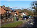
Semis beside the track to Eudon Mill
A row of houses beside the track and footpath. The furthest one is a new build.
Image: © Richard Law
Taken: 16 Feb 2014
0.03 miles
2
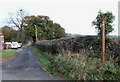
Public Footpath near Eudon George, Shropshire
The first stretch of this path is an unmetalled road serving a few houses on the left.
Image: © Roger D Kidd
Taken: 17 Nov 2007
0.06 miles
5
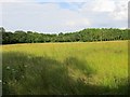
Long grass, Eudon
Awaiting cutting, probably for silage.
Image: © Richard Webb
Taken: 30 Jun 2014
0.24 miles