IMAGES TAKEN NEAR TO
Glazeley, BRIDGNORTH, WV16 6AA
Introduction
This page details the photographs taken nearby to WV16 6AA by members of the Geograph project.
The Geograph project started in 2005 with the aim of publishing, organising and preserving representative images for every square kilometre of Great Britain, Ireland and the Isle of Man.

There are currently over 7.5m images from over14,400 individuals and you can help contribute to the project by visiting https://www.geograph.org.uk
Image Map
Images are licensed for reuse under creativecommons.org/licenses/by-sa/2.0
Notes
- Clicking on the map will re-center to the selected point.
- The higher the marker number, the further away the image location is from the centre of the postcode.
Image Listing (6 Images Found)
Images are licensed for reuse under creativecommons.org/licenses/by-sa/2.0
Image
Details
Distance
3
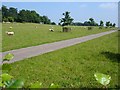
Driveway to Woodlands
With freshly shorn sheep in the park.
Image: © Penny Mayes
Taken: 6 Jun 2007
0.20 miles
4
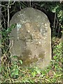
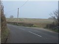
Old Milestone by the B4363, Eudon Burnell, Chetton Parish
Stone post (plate lost) by the B4363, in parish of CHETTON (BRIDGNORTH District), Eudon Burnell, just North of Woodlands Lodge in hedgerow, on West side of road. Cleobury iron plate, erected by the Cleobury Mortimer to Bridgnorth turnpike trust in the 19th century.
Inscription once read:-
(BRIDGNORTH)
(3 MILES)
(CLEOBURY MORTR)
(11 MILES)
Carved benchmark front bottom right.
Milestone Society National ID: SA_BNCM03.
Image: © A Reade/M Faherty
Taken: 8 Feb 2008
0.20 miles
6
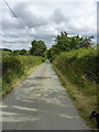
Towards Spring Cottages
The narrow lane from the Ludlow road near The Down pub, which comes out on the Cleobury Mortimer road at Spring Cottages.
Image: © Richard Law
Taken: 9 Aug 2015
0.22 miles