IMAGES TAKEN NEAR TO
Orchard Close, BRIDGNORTH, WV16 5JX
Introduction
This page details the photographs taken nearby to Orchard Close, WV16 5JX by members of the Geograph project.
The Geograph project started in 2005 with the aim of publishing, organising and preserving representative images for every square kilometre of Great Britain, Ireland and the Isle of Man.

There are currently over 7.5m images from over14,400 individuals and you can help contribute to the project by visiting https://www.geograph.org.uk
Image Map
Images are licensed for reuse under creativecommons.org/licenses/by-sa/2.0
Notes
- Clicking on the map will re-center to the selected point.
- The higher the marker number, the further away the image location is from the centre of the postcode.
Image Listing (13 Images Found)
Images are licensed for reuse under creativecommons.org/licenses/by-sa/2.0
Image
Details
Distance
5
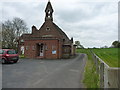
Eardington school
The former school in the village; there seems to be little information available online about this building, but it's now found a new use as a village hall.
Image: © Richard Law
Taken: 19 Apr 2015
0.14 miles
6
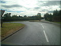
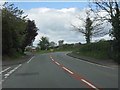
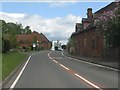
Road junction
Road junction at the north of Eardington village
Image: © planetearthisblue
Taken: 26 Sep 2007
0.15 miles
7
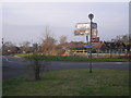
Eardington Summit 210 feet
The highest point on the Severn Valley Railway.
I only just managed to photograph the sign.
Image: © David P Howard
Taken: 15 May 2014
0.20 miles
8
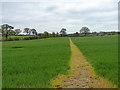
Footpath towards south Eardington
One of several paths across the fields west of the village.
Image: © Richard Law
Taken: 19 Apr 2015
0.21 miles
10
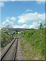
Severn Valley Railway near Eardington in Shropshire
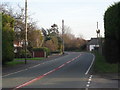
This is the Severn Valley Railway, looking north-west towards Bridgnorth (a mile and a quarter away; about two kilometres). The accommodation bridge (No 31) is for farmer's use. No public right of way crosses it. Some people call it Pig Bridge. https://www.svrwiki.com/Pig_Bridge
The set of track images on this day were obtained by hanging out of the rear door window of the rear carriage of a train destined for Kidderminster; miles away from the steam loco; no smuts in my eye, but plenty of jolts and judders and rocking and rolling resulting in multiple image rotation afterwards to level/straighten them out! :-)
Image: © Roger Kidd
Taken: 14 May 2014
0.23 miles