IMAGES TAKEN NEAR TO
Severn Vale, BRIDGNORTH, WV16 5JW
Introduction
This page details the photographs taken nearby to Severn Vale, WV16 5JW by members of the Geograph project.
The Geograph project started in 2005 with the aim of publishing, organising and preserving representative images for every square kilometre of Great Britain, Ireland and the Isle of Man.

There are currently over 7.5m images from over14,400 individuals and you can help contribute to the project by visiting https://www.geograph.org.uk
Image Map
Images are licensed for reuse under creativecommons.org/licenses/by-sa/2.0
Notes
- Clicking on the map will re-center to the selected point.
- The higher the marker number, the further away the image location is from the centre of the postcode.
Image Listing (8 Images Found)
Images are licensed for reuse under creativecommons.org/licenses/by-sa/2.0
Image
Details
Distance
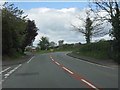
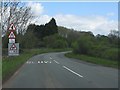
3
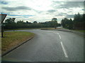
Road junction
Road junction at the north of Eardington village
Image: © planetearthisblue
Taken: 26 Sep 2007
0.05 miles
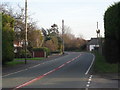
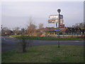
5
Eardington Summit 210 feet
The highest point on the Severn Valley Railway.
I only just managed to photograph the sign.
Image: © David P Howard
Taken: 15 May 2014
0.14 miles
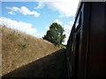
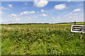
6
Cutting Near Eardington
Not quite at the summit.
Image: © Mary and Angus Hogg
Taken: 15 Oct 2017
0.19 miles