IMAGES TAKEN NEAR TO
Aldenham, BRIDGNORTH, WV16 4TF
Introduction
This page details the photographs taken nearby to WV16 4TF by members of the Geograph project.
The Geograph project started in 2005 with the aim of publishing, organising and preserving representative images for every square kilometre of Great Britain, Ireland and the Isle of Man.

There are currently over 7.5m images from over14,400 individuals and you can help contribute to the project by visiting https://www.geograph.org.uk
Image Map
Images are licensed for reuse under creativecommons.org/licenses/by-sa/2.0
Notes
- Clicking on the map will re-center to the selected point.
- The higher the marker number, the further away the image location is from the centre of the postcode.
Image Listing (8 Images Found)
Images are licensed for reuse under creativecommons.org/licenses/by-sa/2.0
Image
Details
Distance
3
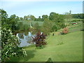
Hurst Farm Fishing Lake
This was taken from the house towards the lake. They were great hosts and it was a very peaceful location.
Image: © Jenni Miller
Taken: 19 May 2007
0.06 miles
4
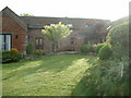
Hurst Farm barn conversion
Beautifully converted barn for self catering accommodation.
Image: © Jenni Miller
Taken: 19 May 2007
0.07 miles
5
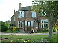
Hurst Farm
Hurst Farmhouse is situated close to the Jack Mytton Way in Bridgnorth Shropshire, not far from Much Wenlock and the Wenlock Edge.
Image: © Jenni Miller
Taken: 19 May 2007
0.08 miles
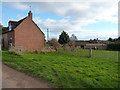
6
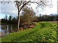
Southern bank of Icehouse Pool
One of three lakes in this valley, the other two being upstream; all have a number of fishing pegs around their sides, but don't appear to see much angling activity.
Image: © Richard Law
Taken: 7 Dec 2013
0.10 miles
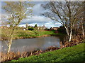
7
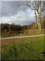
Fishing pool near The Hurst
One of three pools in this tributary valley of the Mor Brook, all of them looking rather muddy; not sure whether that was the residue of last week's rain, or the activity of fish.
Image: © Richard Law
Taken: 7 Dec 2013
0.15 miles
8
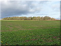
Commonbank copse
A substantial wood to the north of The Hurst farm complex.
Image: © Richard Law
Taken: 7 Dec 2013
0.18 miles