IMAGES TAKEN NEAR TO
Stocking Lane, BRIDGNORTH, WV16 4SY
Introduction
This page details the photographs taken nearby to Stocking Lane, WV16 4SY by members of the Geograph project.
The Geograph project started in 2005 with the aim of publishing, organising and preserving representative images for every square kilometre of Great Britain, Ireland and the Isle of Man.

There are currently over 7.5m images from over14,400 individuals and you can help contribute to the project by visiting https://www.geograph.org.uk
Image Map
Images are licensed for reuse under creativecommons.org/licenses/by-sa/2.0
Notes
- Clicking on the map will re-center to the selected point.
- The higher the marker number, the further away the image location is from the centre of the postcode.
Image Listing (7 Images Found)
Images are licensed for reuse under creativecommons.org/licenses/by-sa/2.0
Image
Details
Distance
1
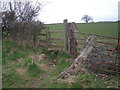
Towards Stocking Lane, near Nordley, Shropshire
The bridleway from Kingsley's Farm follows the field edge here, and enters Stocking Lane (unsurfaced) through the gate in the corner of the field.
Image: © Roger D Kidd
Taken: 2 Nov 2007
0.09 miles
2
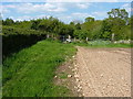
Bridleway gate at the end of Stocking Lane
Image: © Richard Law
Taken: 25 May 2013
0.12 miles
3
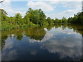
Fishing pool at Toys Rough
Run by one of the Midland's largest clubs - the Birmingham Anglers' Association BAA.
Image: © Richard Law
Taken: 25 May 2013
0.13 miles
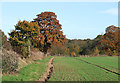
4
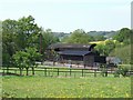
Farm Buildings in Stocking Lane
Quiet spot with more yellow rape fields behind..
Image: © John M
Taken: 28 Apr 2007
0.14 miles
5
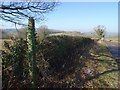
B4373, Nordley
Descent to Lindley Brook with ivy covering a footpath sign.
Image: © Richard Webb
Taken: 15 Feb 2019
0.19 miles
6
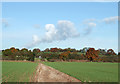
Bridleway over Crop Fields, near Haughton, Shropshire
Image: © Roger D Kidd
Taken: 2 Nov 2007
0.19 miles