IMAGES TAKEN NEAR TO
Colemore Green, BRIDGNORTH, WV16 4ST
Introduction
This page details the photographs taken nearby to Colemore Green, WV16 4ST by members of the Geograph project.
The Geograph project started in 2005 with the aim of publishing, organising and preserving representative images for every square kilometre of Great Britain, Ireland and the Isle of Man.

There are currently over 7.5m images from over14,400 individuals and you can help contribute to the project by visiting https://www.geograph.org.uk
Image Map
Images are licensed for reuse under creativecommons.org/licenses/by-sa/2.0
Notes
- Clicking on the map will re-center to the selected point.
- The higher the marker number, the further away the image location is from the centre of the postcode.
Image Listing (5 Images Found)
Images are licensed for reuse under creativecommons.org/licenses/by-sa/2.0
Image
Details
Distance
1
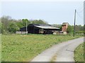
Barns near Colemore Farm
These barns do not seem to be used very much at present.
Image: © John M
Taken: 28 Apr 2007
0.04 miles
2

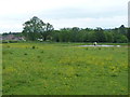
Colemore Green
A collection of houses and smallholdings near Astley Abbots.
Image: © Richard Law
Taken: 5 Jun 2012
0.04 miles
3
Horse and pond in a field at Colemore Green
Image: © Richard Law
Taken: 5 Jun 2012
0.15 miles
4
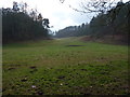
A dry valley near Colemore Green
No sign of any stream in this little valley, which is grazed by livestock from a local farm.
Image: © Richard Law
Taken: 12 Feb 2012
0.16 miles
5
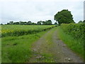
Footpath to Binnal Lane
This path leads to Binnal Cottage, an isolated house in the fields SW of here.
Image: © Richard Law
Taken: 5 Jun 2012
0.23 miles