IMAGES TAKEN NEAR TO
St. Gregorys Close, BRIDGNORTH, WV16 4RL
Introduction
This page details the photographs taken nearby to St. Gregorys Close, WV16 4RL by members of the Geograph project.
The Geograph project started in 2005 with the aim of publishing, organising and preserving representative images for every square kilometre of Great Britain, Ireland and the Isle of Man.

There are currently over 7.5m images from over14,400 individuals and you can help contribute to the project by visiting https://www.geograph.org.uk
Image Map
Images are licensed for reuse under creativecommons.org/licenses/by-sa/2.0
Notes
- Clicking on the map will re-center to the selected point.
- The higher the marker number, the further away the image location is from the centre of the postcode.
Image Listing (116 Images Found)
Images are licensed for reuse under creativecommons.org/licenses/by-sa/2.0
Image
Details
Distance
1
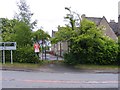
Morville Primary School
The view in Morville Village, Shropshire.
Image: © Gordon Griffiths
Taken: 12 May 2017
0.03 miles
2
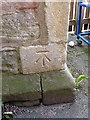
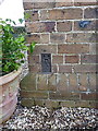
OS benchmark - Morville school
An OS cutmark in the stonework of the school at Morville; originally levelled at 93.96m above Ordnance Datum Newlyn.
Image: © Richard Law
Taken: 7 Dec 2013
0.04 miles
3
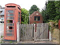
K6 Telephone Box and Telephone Exchange, Morville
Situated on the A458 road, the telephone box and adjacent telephone exchange is still quite a common sight in rural areas, both dating from the GPO era. The telephone box is missing a few glass panes and is leaning somewhat. It remains to be seen how long it will remain there. A red post box can just be seen to the extreme right of the photo. Update: the telephone box now has a defibrillator inside it instead of a payphone.
Image: © David Hillas
Taken: 20 Jul 2018
0.04 miles
4
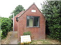
Morville Telephone Exchange
Situated on the A458 road, this redbrick TE comprises of two buildings, the front one dating from the GPO era, and has the code CMMOR. It provides telephone and broadband services to 211 residential and 34 non-residential premises in Morville plus Acton Round, Aston Eyre, Haughton and Upton Cressett nearby. A yellow grit salt bin can be seen in front of this TE. The numbering range of this TE is (01746) 714xxx, the (01746) referring to the Bridgnorth group of twelve TEs, and its postcode is WV16 4RJ.
Image: © David Hillas
Taken: 20 Jul 2018
0.04 miles
5
OS Flush Bracket G2199 - Morville
An OS flush bracket on the N wall of the former police house at Morville, now privately owned. Originally levelled at 96.72m above Ordnance Datum Newlyn when it was installed in 1952.
Image: © Richard Law
Taken: 7 Dec 2013
0.04 miles
6
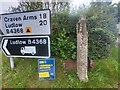
Direction Sign - Signpost at Morville
Located on the northwest side of the junction of the A458 and the B4368 Ludlow Road. Morville parish. no arms and no finial. Grade II Listed details https://historicengland.org.uk/listing/the-list/list-entry/1449498. This dates from the late C18 or early C19.
Milestone Society National ID: SA_SO6694
Image: © D Phillips
Taken: 1 Oct 2023
0.05 miles
7
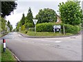
Ludlow Road
The view of the B4368 road to Craven Arms and Ludlow at Morville.
Image: © Gordon Griffiths
Taken: 12 May 2017
0.07 miles
8

Hall Drive
The view down the drive from Morville Hall, Shropshire.
Image: © Gordon Griffiths
Taken: 12 May 2017
0.07 miles
9
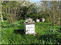
Bee hives
These are the bee hives in the grounds of The Dower House at Morville Hall.
They are surrounded by blossom and snowdrops at this time of the year.
Image: © Carol Walker
Taken: 17 Apr 2009
0.07 miles
10
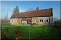
Morville Barn
This barn or block of stables on the Morville Hall estate has recently been converted to a pair of holiday cottages. Compare with Image
Image: © Ian Taylor
Taken: 24 Feb 2024
0.08 miles