IMAGES TAKEN NEAR TO
The Croft, BRIDGNORTH, WV16 4RG
Introduction
This page details the photographs taken nearby to The Croft, WV16 4RG by members of the Geograph project.
The Geograph project started in 2005 with the aim of publishing, organising and preserving representative images for every square kilometre of Great Britain, Ireland and the Isle of Man.

There are currently over 7.5m images from over14,400 individuals and you can help contribute to the project by visiting https://www.geograph.org.uk
Image Map
Images are licensed for reuse under creativecommons.org/licenses/by-sa/2.0
Notes
- Clicking on the map will re-center to the selected point.
- The higher the marker number, the further away the image location is from the centre of the postcode.
Image Listing (8 Images Found)
Images are licensed for reuse under creativecommons.org/licenses/by-sa/2.0
Image
Details
Distance
1
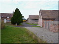
Barn conversions at The Croft
A bridleway runs right through the farmyard, past these rather good conversions.
Image: © Richard Law
Taken: 30 Oct 2011
0.01 miles
2
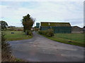
Bridleway and entrance to The Croft farm
Image: © Richard Law
Taken: 30 Oct 2011
0.07 miles

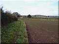
5
Large Field
With the sun low in the sky (and my shadow showing) lovely lighting across a large field. I'm not sure if the buildings in the distance are Aldenham Park?
Image: © Charles Joynson
Taken: 20 Jan 2007
0.16 miles

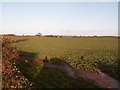
7
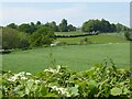
View to Aldenham Park
Aldenham Park viewed across farmland from the south-east.
Image: © Philip Halling
Taken: 2 Jun 2021
0.18 miles
8
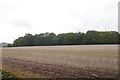
Oilseed rape stubble, Morville
Field beside Cuckoopit Coppice.
Image: © Richard Webb
Taken: 15 Oct 2019
0.21 miles