IMAGES TAKEN NEAR TO
Connaught Road, WOLVERHAMPTON, WV1 4SQ
Introduction
This page details the photographs taken nearby to Connaught Road, WV1 4SQ by members of the Geograph project.
The Geograph project started in 2005 with the aim of publishing, organising and preserving representative images for every square kilometre of Great Britain, Ireland and the Isle of Man.

There are currently over 7.5m images from over14,400 individuals and you can help contribute to the project by visiting https://www.geograph.org.uk
Image Map
Images are licensed for reuse under creativecommons.org/licenses/by-sa/2.0
Notes
- Clicking on the map will re-center to the selected point.
- The higher the marker number, the further away the image location is from the centre of the postcode.
Image Listing (209 Images Found)
Images are licensed for reuse under creativecommons.org/licenses/by-sa/2.0
Image
Details
Distance
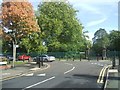
1
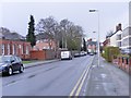
Connaught Road
The view in Wolverhampton near the West Park.
Image: © Gordon Griffiths
Taken: 23 Mar 2014
0.01 miles
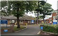
2
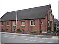
West Park Church
This church, on Connaught Road, is very close to West Park.
Image: © Angella Streluk
Taken: 22 Apr 2006
0.02 miles
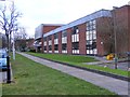
3
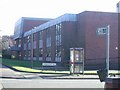
West Park Rehabilitation Hospital
The rehabilitation hospital overlooking the West Park is run by the Wolverhampton Primary Care Trust.
Image: © John M
Taken: 11 Feb 2007
0.03 miles
4
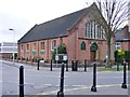
West Park Church
The view of the Independent Evangelical Church overlooking the West Park in Wolverhampton.
Image: © Gordon Griffiths
Taken: 2 Feb 2014
0.04 miles
5
West Park
The park was opened in 1881 and is a fine example of a formal Victorian Park with lake, conservatory and bandstand.
Image: © John M
Taken: 2 Oct 2010
0.05 miles
6
West Park Hospital
The rehabilitation centre overlooking the West Park is run by the Wolverhampton Primary Care Trust, and stands on the site of the former Women's Hospital open in 1904.
Image: © Gordon Griffiths
Taken: 2 Feb 2014
0.05 miles
8
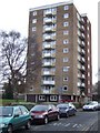
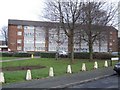
Council Housing - Connaught House
The 1960s Vauxhall Estate has three tower and three lower height blocks of flats. These replaced Victorian terrace housing between Tettenhall Road and West Park.
Image: © John M
Taken: 11 Dec 2010
0.06 miles
9
Council Housing - Upper Vauxhall
The 1960s Vauxhall Estate sandwiched between Tettenhall Road and West Park comprises medium and high rise blocks. The small estate replaced Victorian terraced properties. The estate lies within the Park Conservation Area.
Image: © John M
Taken: 11 Dec 2010
0.06 miles
10
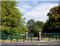
Gateway into West Park, Wolverhampton
The actual Victorian perimeter gates and cast iron railings are Grade II listed. This is the entrance in Park Road West, opposite Connaught Road.
Image: © Roger D Kidd
Taken: 13 Oct 2010
0.06 miles