IMAGES TAKEN NEAR TO
Bath Road, WOLVERHAMPTON, WV1 4EL
Introduction
This page details the photographs taken nearby to Bath Road, WV1 4EL by members of the Geograph project.
The Geograph project started in 2005 with the aim of publishing, organising and preserving representative images for every square kilometre of Great Britain, Ireland and the Isle of Man.

There are currently over 7.5m images from over14,400 individuals and you can help contribute to the project by visiting https://www.geograph.org.uk
Image Map
Images are licensed for reuse under creativecommons.org/licenses/by-sa/2.0
Notes
- Clicking on the map will re-center to the selected point.
- The higher the marker number, the further away the image location is from the centre of the postcode.
Image Listing (411 Images Found)
Images are licensed for reuse under creativecommons.org/licenses/by-sa/2.0
Image
Details
Distance
1
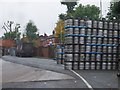
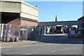
Beer Barrel Rack
The view at Banks's Brewery off Bath Road, Wolverhampton.
Image: © Gordon Griffiths
Taken: 24 Oct 2012
0.02 miles
2
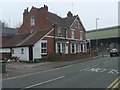
The Old Bookshop
The second hand book shop on the corner of Bath Road and Southgate. The view from near the Wolverhampton West Park with the Banks Brewery in the background.
Image: © Gordon Griffiths
Taken: 26 Mar 2011
0.02 miles
3
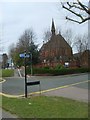
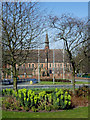
The Kings Church
The church in Park Crescent viewed from the Ring Road.
Image: © Gordon Griffiths
Taken: 9 Apr 2007
0.03 miles
4
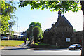
Rhema Faith Church
A charismatic church which has succeeded in this building from King's Church.
Image: © Bill Boaden
Taken: 22 Jun 2018
0.03 miles
5
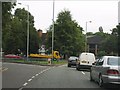
Wolverhampton Ring Road - Bath Street junction
Image: © J Whatley
Taken: 6 Sep 2010
0.04 miles
6
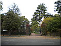
Southgate entrance, West Park, Wolverhampton
Image: © Richard Vince
Taken: 24 Sep 2017
0.05 miles
7
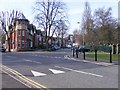
Ring Road view in Wolverhampton
Looking north from near Chapel Ash Island.
Part of the building seen ahead is a dental surgery.
Image: © Roger D Kidd
Taken: 9 Mar 2014
0.05 miles
8
Entrance to Banks's Brewery
Part of the Marston's group with nationwide distribution requirements.
Image: © Bill Boaden
Taken: 22 Jun 2018
0.05 miles
9
Park and Church by Wolverhampton Ring Road
From here at the Chapel Ash roundabout, clockwise to the crossroads at Waterloo Road, the two carriageways of the ring road are separated by a wide and attractively landscaped strip of public parkland. Mature trees and bushes are augmented by well attended grassy areas with cast iron framed seats. The white building is occupied by a dentist practice. The redbrick is the Rhema Faith (Apostolic) Church, sometimes called the King's Church. It was purpose built in 1892-3 as a Catholic Apostolic church, and was locally listed in 2004.
Image: © Roger D Kidd
Taken: 9 Mar 2014
0.05 miles
10
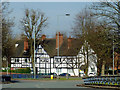
Park Corner
The view by Wolverhampton's West Park at the junction of Park Road and Park Crescent.
Image: © Gordon Griffiths
Taken: 10 Apr 2010
0.05 miles