IMAGES TAKEN NEAR TO
Stowmans Close, BILSTON, WV14 9YB
Introduction
This page details the photographs taken nearby to Stowmans Close, WV14 9YB by members of the Geograph project.
The Geograph project started in 2005 with the aim of publishing, organising and preserving representative images for every square kilometre of Great Britain, Ireland and the Isle of Man.

There are currently over 7.5m images from over14,400 individuals and you can help contribute to the project by visiting https://www.geograph.org.uk
Image Map
Images are licensed for reuse under creativecommons.org/licenses/by-sa/2.0
Notes
- Clicking on the map will re-center to the selected point.
- The higher the marker number, the further away the image location is from the centre of the postcode.
Image Listing (174 Images Found)
Images are licensed for reuse under creativecommons.org/licenses/by-sa/2.0
Image
Details
Distance
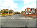
1
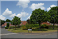
Stowmans Close in Sedgemoor Park, Wolverhampton
Looking north-east from Turtons Croft.
Stowmans Close is a cul-de-sac off a cul-de-sac!
The Sedgemoor Park estate has been built on the site of the former Spring Vale colliery.
Image: © Roger Kidd
Taken: 20 Jul 2021
0.02 miles
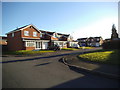
2
Turtons Croft View
The view of the end of the close in Spring Vale Estate, Wolverhampton.
Image: © Gordon Griffiths
Taken: 16 Dec 2013
0.03 miles
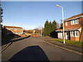
3
Turtons Croft in Sedgemoor Park, Wolverhampton
Looking north-east, Turtons Croft is a cul-de-sac off Overfield Drive. The estate has been built on the site of the former Spring Vale colliery. A footpath does continue across the Birmingham Canal Navigations Main Line between Wolverhampton and Birmingham.
Image: © Roger Kidd
Taken: 20 Jul 2021
0.04 miles
4
Turtons Croft in Sedgemoor Park, Wolverhampton
Turtons Croft is a cul-de-sac off Overfield Drive. The estate has been built on the site of the former Spring Vale colliery. A footpath does lead across the Birmingham Canal Navigations Main Line between Wolverhampton and Birmingham.
Image: © Roger Kidd
Taken: 20 Jul 2021
0.04 miles
5
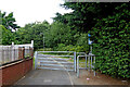
Footpath north from Sedgemoor Park in Wolverhampton
The footpath leads across Turtons Croft Footbridge (Ten Score Bridge), over the Birmingham Canal Navigations Main Line between Wolverhampton and Birmingham.
Image: © Roger Kidd
Taken: 20 Jul 2021
0.04 miles
6
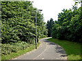
Footpath to Sedgemoor Park, Wolverhampton
Looking south-east towards Turtons Croft. The footpath cross the canal behind the camera.
Image: © Roger Kidd
Taken: 20 Jul 2021
0.04 miles
7
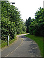
Footpath to Sedgemoor Park, Wolverhampton
Looking south-east towards Turtons Croft. The footpath cross the canal behind the camera.
Image: © Roger Kidd
Taken: 20 Jul 2021
0.04 miles
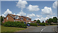
8
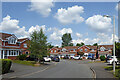
Housing in Turtons Croft, Spring Vale, Wolverhampton
Looking north-east, Turtons Croft is a cul-de-sac off Overfield Drive. Kempsons Grove is off to the right.
The Sedgemoor Park estate has been built on the site of the former Spring Vale colliery. A footpath does continue across the Birmingham Canal Navigations Main Line between Wolverhampton and Birmingham.
Image: © Roger Kidd
Taken: 20 Jul 2021
0.05 miles
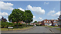
9
Turtons Croft
The view from Overfield Drive in Spring Vale, Wolverhampton.
Image: © Gordon Griffiths
Taken: 24 May 2013
0.05 miles
10
Moss Gardens
The view in Spring Vale, Wolverhampton.
Image: © Gordon Griffiths
Taken: 16 Dec 2013
0.05 miles