IMAGES TAKEN NEAR TO
Capponfield Close, BILSTON, WV14 9XL
Introduction
This page details the photographs taken nearby to Capponfield Close, WV14 9XL by members of the Geograph project.
The Geograph project started in 2005 with the aim of publishing, organising and preserving representative images for every square kilometre of Great Britain, Ireland and the Isle of Man.

There are currently over 7.5m images from over14,400 individuals and you can help contribute to the project by visiting https://www.geograph.org.uk
Image Map
Images are licensed for reuse under creativecommons.org/licenses/by-sa/2.0
Notes
- Clicking on the map will re-center to the selected point.
- The higher the marker number, the further away the image location is from the centre of the postcode.
Image Listing (249 Images Found)
Images are licensed for reuse under creativecommons.org/licenses/by-sa/2.0
Image
Details
Distance
1
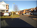
Capponfield Close End
The view of the Close in Spring Vale, Wolverhampton.
Image: © Gordon Griffiths
Taken: 16 Dec 2013
0.03 miles
2

Finney Well Close
The view of the Close on Spring Vale Estate, Wolverhampton.
Image: © Gordon Griffiths
Taken: 16 Dec 2013
0.04 miles
3
Capponfield Close View
The view from Overfield Drive in Spring Vale, Wolverhampton.
Image: © Gordon Griffiths
Taken: 13 Dec 2013
0.04 miles
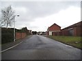
4
Capponfield Close in Sedgemoor Park, Wolverhampton
Looking north-east from the junction with Overfield Drive. The area was formerly covered with coal pits including the Spring Vale Colliery, which closed in 1890.
Note: The Capponfield Colliery was about six hundred metres to the east by the Ladymoor Pool.
Image: © Roger Kidd
Taken: 20 Jul 2021
0.04 miles
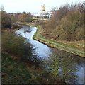
5
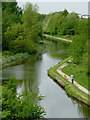
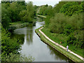
The canal at Spring Vale, Wolverhampton
Seen looking towards Wolverhampton from the Black Country Route (A463) bridge, the Birmingham Canal Navigations Main Line canal (Wolverhampton Level) was opened in 1769 by the Birmingham Canal Company, engineered by James Brindley, and partially rerouted by Telford in 1837. The towpath has been restored and is now a designated off-road cycle way.
Image: © Roger D Kidd
Taken: 30 Apr 2014
0.06 miles
6
The canal at Spring Vale, Wolverhampton
Looking towards Wolverhampton from the Black Country Route (A463) bridge, the Birmingham Canal Navigations Main Line canal (Wolverhampton Level) was opened in 1769 by the Birmingham Canal Company, engineered by James Brindley, and partially rerouted by Telford in 1837. The towpath has been restored and is now a designated off-road cycle way.
Image: © Roger D Kidd
Taken: 30 Apr 2014
0.06 miles
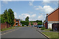
7
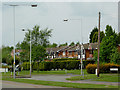
Housing in Spring Vale, Wolverhampton
The image shows the view across the roundabout at the junction with Overfield Drive.
Image: © Roger D Kidd
Taken: 30 Apr 2014
0.06 miles
8
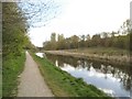
Spring Vale Canal
The view along the Birmingham Canal in Bilston.
Image: © Gordon Griffiths
Taken: 11 Apr 2014
0.06 miles
9
Black Country Canal
The view along the Birmingham Canal in Spring Vale, Bilston.
Image: © Gordon Griffiths
Taken: 28 Mar 2013
0.06 miles
10
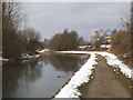
BCN Canal at Spring Vale, Wolverhampton
This is the Birmingham Main Line to Wolverhampton opened in 1769 by the Birmingham Canal Company, engineered by James Brindley. Today there is slight icing by the west bank after several fairly cold nights.
Image: © Roger D Kidd
Taken: 23 Dec 2007
0.06 miles