IMAGES TAKEN NEAR TO
Baldwin Street, BILSTON, WV14 8NX
Introduction
This page details the photographs taken nearby to Baldwin Street, WV14 8NX by members of the Geograph project.
The Geograph project started in 2005 with the aim of publishing, organising and preserving representative images for every square kilometre of Great Britain, Ireland and the Isle of Man.

There are currently over 7.5m images from over14,400 individuals and you can help contribute to the project by visiting https://www.geograph.org.uk
Image Map
Images are licensed for reuse under creativecommons.org/licenses/by-sa/2.0
Notes
- Clicking on the map will re-center to the selected point.
- The higher the marker number, the further away the image location is from the centre of the postcode.
Image Listing (105 Images Found)
Images are licensed for reuse under creativecommons.org/licenses/by-sa/2.0
Image
Details
Distance
1

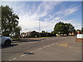
St Martin's Terrace
The view from Baldwin Street in Bilston.
Image: © Gordon Griffiths
Taken: 10 Jun 2014
0.03 miles
2
Salop Street View
The view from Greenway Road in Bradley, Bilston.
Image: © Gordon Griffiths
Taken: 25 May 2014
0.03 miles
3
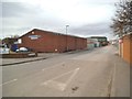
Greenway Road
The view of a Industrial Area of Bradley, Bilston.
Image: © Gordon Griffiths
Taken: 22 Feb 2014
0.06 miles
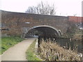
4
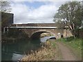
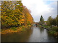
Pot House Bridge - Bradley Arm Canal
A remnant of James Brindley's Old Main Line from Wolverhampton to Birmingham. This section of the Wednesbury Oak Loop declined following the opening of Thomas Telford's New Main Line through Coseley Tunnel in 1837. The canal is infilled beyond the British Waterways workshops at Bradley.
Image: © John M
Taken: 4 Apr 2009
0.06 miles
5
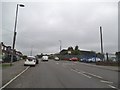
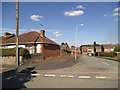
Salop Road View
The view down the Bradley street in Bilston. The White Hart Pub entrance is on the left of the picture.Image
Image: © Gordon Griffiths
Taken: 29 May 2014
0.06 miles
6
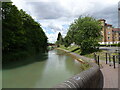
Wednesbury Oak Loop, Bradley (1)
Approaching Pothouse Bridge, which carries Loxdale Street across the canal.
Image: © Richard Vince
Taken: 20 Oct 2018
0.07 miles
7
Kemsey Drive
The view of the drive from Walter Road in Bradley, Bilston.
Image: © Gordon Griffiths
Taken: 12 Jun 2014
0.07 miles
8
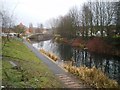
The Bradley Arm of the Birmingham Canal Navigations, at Pot House Bridge
Originally part of the Wednesbury Oak Loop, this part of the canal network fell into much-reduced use once the Coseley Tunnel opened in 1837 (pictures in Image), and has been closed to boat traffic completely now.
Image: © Richard Law
Taken: 28 Jan 2009
0.07 miles
9
Loxdale Sidings View
The view in Bilston with a housing development on the right, alongside the Bradley Leg Canal.
Image: © Gordon Griffiths
Taken: 30 Jun 2022
0.07 miles
10
Pot House Bridge
The view of the bridge carrying Salop Street over the Bradley Leg Canal in Bilston.
Image: © Gordon Griffiths
Taken: 22 Feb 2014
0.07 miles