IMAGES TAKEN NEAR TO
Sycamore Place, BILSTON, WV14 8BY
Introduction
This page details the photographs taken nearby to Sycamore Place, WV14 8BY by members of the Geograph project.
The Geograph project started in 2005 with the aim of publishing, organising and preserving representative images for every square kilometre of Great Britain, Ireland and the Isle of Man.

There are currently over 7.5m images from over14,400 individuals and you can help contribute to the project by visiting https://www.geograph.org.uk
Image Map
Images are licensed for reuse under creativecommons.org/licenses/by-sa/2.0
Notes
- Clicking on the map will re-center to the selected point.
- The higher the marker number, the further away the image location is from the centre of the postcode.
Image Listing (62 Images Found)
Images are licensed for reuse under creativecommons.org/licenses/by-sa/2.0
Image
Details
Distance
1

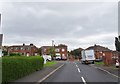
Willis Pearson Avenue Junction
The view of the junction with Wallace Road in Bradley, Bilston.
Image: © Gordon Griffiths
Taken: 16 Jul 2014
0.06 miles
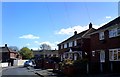
2
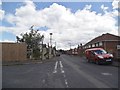
Mervyn Road View
The view of the junction with Wallace Road in Bradley, Bilston.
Image: © Gordon Griffiths
Taken: 3 Sep 2019
0.08 miles
3
Willis Pearson Avenue
The view from Rowley View in Bradley, Bilston.
Image: © Gordon Griffiths
Taken: 10 Jun 2014
0.08 miles
4
St Martin's School
The view in Wallace Road, Bilston.
Image: © Gordon Griffiths
Taken: 19 Apr 2017
0.08 miles
5
Mervyn Place View
The view down Mervyn Road in Bradley, Bilston.
Image: © Gordon Griffiths
Taken: 4 Jun 2014
0.09 miles
6
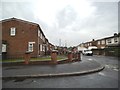
Housing in Bradley Lane
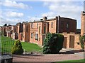
This unusual row of 1920s housing has retained a lot of the original features. Bilston UDC built 124 examples of this squat style of property around the borough in 1922.
Image: © John M
Taken: 7 Oct 2006
0.11 miles
7
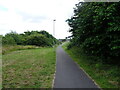
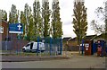
Bradley Lane Path
The view of the footpath in Bilston near the Midland Metro line.
Image: © Gordon Griffiths
Taken: 30 Jun 2022
0.12 miles
8
Bellevue Road
The view towards Wallace Road in Bradley, Bilston.
Image: © Gordon Griffiths
Taken: 21 Apr 2017
0.12 miles
9
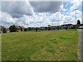
Bradley Playground
The view in Lower Bradley, West Midlands.
Image: © Gordon Griffiths
Taken: 30 Jun 2022
0.13 miles
10
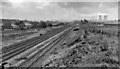
Site of Bradley & Moxley Station
View SE, towards Birmingham; ex-GWR Birmingham Snow Hill - Wolverhampton - Shrewsbury Main line. This station had been closed as long ago as 1/5/15 and the main line was closed (Birmingham - Wolverhampton) on 6/3/72, but in 1999 much of the route was incorporated in the new Midland Metro and a station was built at Bradley Lane, a short distance northward (behind camera).
Image: © Ben Brooksbank
Taken: 4 Sep 1962
0.13 miles