IMAGES TAKEN NEAR TO
Lavender Grove, BILSTON, WV14 7HB
Introduction
This page details the photographs taken nearby to Lavender Grove, WV14 7HB by members of the Geograph project.
The Geograph project started in 2005 with the aim of publishing, organising and preserving representative images for every square kilometre of Great Britain, Ireland and the Isle of Man.

There are currently over 7.5m images from over14,400 individuals and you can help contribute to the project by visiting https://www.geograph.org.uk
Image Map
Images are licensed for reuse under creativecommons.org/licenses/by-sa/2.0
Notes
- Clicking on the map will re-center to the selected point.
- The higher the marker number, the further away the image location is from the centre of the postcode.
Image Listing (86 Images Found)
Images are licensed for reuse under creativecommons.org/licenses/by-sa/2.0
Image
Details
Distance
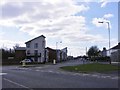
1
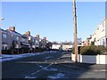
Hatherton Road View
The view down Lavender Grove, Bilston.
Image: © Gordon Griffiths
Taken: 8 Dec 2010
0.01 miles
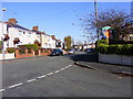
2
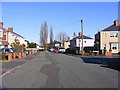
Lavender Grove Junction
The view down Vernon Road Bilston.
Image: © Gordon Griffiths
Taken: 10 Nov 2010
0.03 miles
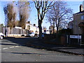
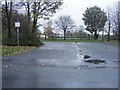
3

Lavender Grove
The view on the Lunt Estate, Bilston.
Image: © Gordon Griffiths
Taken: 1 Nov 2010
0.07 miles
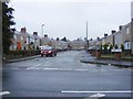
4
Vernon Road View
The view of Lonsdale Road Bilston.
Image: © Gordon Griffiths
Taken: 10 Nov 2010
0.07 miles
5
Garden Walk
A Close on the Lunt Estate, Bilston.
Image: © Gordon Griffiths
Taken: 8 Nov 2010
0.07 miles
6
Sculpture Route Sign
The view of the Black Country Sculpture Route sign off Lunt Road, Bilston. The sign is at the start of the Magic Forest between Lunt Road and Darlaston Lane which features twelve sculptures.
Image: © Gordon Griffiths
Taken: 1 Nov 2010
0.08 miles
7
Vernon Road
A road on the Lunt Estate, Bilston.
Image: © Gordon Griffiths
Taken: 10 Nov 2010
0.08 miles
8

Lunt Road Path
A footpath starts from Lunt Road near the Black Country Route in Bilston.
Image: © Gordon Griffiths
Taken: 16 Aug 2011
0.09 miles
9
Lunt Road Flats
The view of the new Flats on the Lunt Estate, Bilston. The Flats were built on the wasteground shown in December 2010.Image
Image: © Gordon Griffiths
Taken: 20 Mar 2012
0.09 miles
10
Green Acres Field
The view of the Primary School playing fields from Beckett Street, Bilston.
Image: © Gordon Griffiths
Taken: 8 Nov 2010
0.10 miles