IMAGES TAKEN NEAR TO
Queen Street, BILSTON, WV14 7ER
Introduction
This page details the photographs taken nearby to Queen Street, WV14 7ER by members of the Geograph project.
The Geograph project started in 2005 with the aim of publishing, organising and preserving representative images for every square kilometre of Great Britain, Ireland and the Isle of Man.

There are currently over 7.5m images from over14,400 individuals and you can help contribute to the project by visiting https://www.geograph.org.uk
Image Map
Images are licensed for reuse under creativecommons.org/licenses/by-sa/2.0
Notes
- Clicking on the map will re-center to the selected point.
- The higher the marker number, the further away the image location is from the centre of the postcode.
Image Listing (232 Images Found)
Images are licensed for reuse under creativecommons.org/licenses/by-sa/2.0
Image
Details
Distance
1
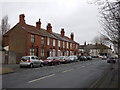
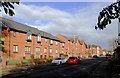
Houses on Queen Street (1)
What appears to be a row of standard terraced houses repays a closer look, as there appear to be three different sizes of house. The nearest house has the luxury of a double front. Where there is a through passage to the rear, one neighbouring house has a small additional room above, probably front and rear. The division between the houses is highlighted by the roofs, where different owners have modernised with different finishes. This is all seen to better effect in this view http://www.geograph.org.uk/photo/2814212
A feature of this terrace is the use of terracotta for the window hood mouldings.
Image: © Alan Murray-Rust
Taken: 14 Feb 2012
0.01 miles
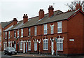
2
Houses on Queen Street (2)
The treatment of the roofs shows that the houses in the terrace are not of identical size. See http://www.geograph.org.uk/photo/2814211
Image: © Alan Murray-Rust
Taken: 14 Feb 2012
0.01 miles
3
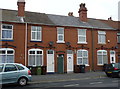
Terraced housing in Bilston, Wolverhampton
This solid looking late Victorian row is in Queen Street at the southern end of Ashley Street. The new housing beyond is very recent, the land still showing as disused on currently available satellite images.
Image: © Roger D Kidd
Taken: 14 Feb 2012
0.02 miles
4
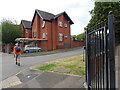
Crossfield Way
The view from Queen Street in Bilston on the site of the former Etheridge Boys School.
Image: © Gordon Griffiths
Taken: 15 Jul 2022
0.03 miles
5
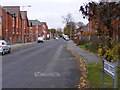
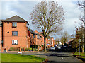
Modern housing in Queen Street, Bilston, Wolverhampton
This is Queen Street, east of Bilston town centre, looking north-west from near Bridge Street.
Image: © Roger D Kidd
Taken: 10 Nov 2017
0.03 miles
6
Queen Street
The view in Bilston near the Black Country Route. The buildings on the left on the former Etheridge School Site.
Image: © Gordon Griffiths
Taken: 3 Nov 2010
0.04 miles
7
Hilton Place
A Close off Queen Street on the Lunt Estate, Bilston.
Image: © Gordon Griffiths
Taken: 8 Nov 2010
0.05 miles
8
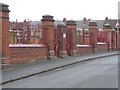
Ashley Street Gate
The Gate of the former Etheridge Infants School now part of the surround of Holy Trinity Catholic Primary School.
Image: © Gordon Griffiths
Taken: 14 Nov 2010
0.05 miles
9
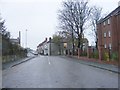
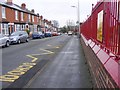
Queen Street in Bilston, Wolverhampton
Queen Street in Bilston is seen here, looking north-east from the junction with Bridge Street.
Image: © Roger D Kidd
Taken: 10 Nov 2017
0.06 miles
10
Ashley Street Scene
The view along side the railings of the former Etheridge School now the Holy Trinity Primary School.
Image: © Gordon Griffiths
Taken: 14 Nov 2010
0.06 miles