IMAGES TAKEN NEAR TO
Oxford Street, BILSTON, WV14 7DE
Introduction
This page details the photographs taken nearby to Oxford Street, WV14 7DE by members of the Geograph project.
The Geograph project started in 2005 with the aim of publishing, organising and preserving representative images for every square kilometre of Great Britain, Ireland and the Isle of Man.

There are currently over 7.5m images from over14,400 individuals and you can help contribute to the project by visiting https://www.geograph.org.uk
Image Map
Images are licensed for reuse under creativecommons.org/licenses/by-sa/2.0
Notes
- Clicking on the map will re-center to the selected point.
- The higher the marker number, the further away the image location is from the centre of the postcode.
Image Listing (493 Images Found)
Images are licensed for reuse under creativecommons.org/licenses/by-sa/2.0
Image
Details
Distance
1
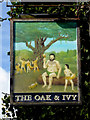
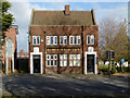
The Oak & Ivy
The Bilston Pub stands on Oxford Street.
Image: © Gordon Griffiths
Taken: 9 Jun 2008
0.01 miles
2
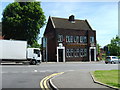
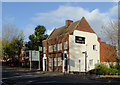
Oxford Street in Bilston, Wolverhampton
This is the A41 passing through Bilston on its way towards Wolverhampton city centre. The Oak and Ivy public house (a locally listed building) is north-west of the Oxford Street roundabout.
Image: © Roger D Kidd
Taken: 10 Nov 2017
0.01 miles
3
The Oak and Ivy pub sign in Bilston, Wolverhampton
This locally listed building is in Oxford Street (A41) north-east of the Oxford Street roundabout.
Image]
Image: © Roger D Kidd
Taken: 10 Nov 2017
0.02 miles
4
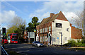
The Oak and Ivy in Bilston, Wolverhampton
This locally listed building is in Oxford Street north-east of the Oxford Street roundabout.
Image: © Roger D Kidd
Taken: 10 Nov 2017
0.02 miles
5
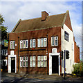
The Oak and Ivy in Bilston, Wolverhampton
This locally listed building is in Oxford Street (A41) north-east of the Oxford Street roundabout.
Image: © Roger D Kidd
Taken: 10 Nov 2017
0.02 miles
6
The Oak and Ivy in Bilston, Wolverhampton
This locally listed building is in Oxford Street (A41) north-east of the Oxford Street roundabout.
Image: © Roger D Kidd
Taken: 10 Nov 2017
0.02 miles
7
Church of God of Prophecy
The Bilston Church in Bridge Street in the former Etheridge School Canteen.
Image: © Gordon Griffiths
Taken: 3 Nov 2010
0.03 miles
8
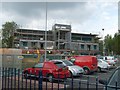
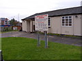
New Police Station
The new Bilston Police Station is being built in Lichfield Street near the Black Country Route to replace the old one in Mount Pleasant.Image
Image: © Gordon Griffiths
Taken: 12 May 2010
0.03 miles
9
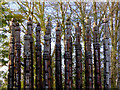
Steel Columns (sculpture) in Bilston, Wolverhampton
Steel Columns (1997) by Robert Koenig is made from fifteen lengths of sweet chestnut up to six metres in height. They refer to Bilston's steel making background. The figures are based on old Victorian photographs.
There are nineteen Black Country Route sculptures by nineteen different artists. These varied works reflect both the area’s heritage and its promise for the future. This one can be seen by Oxford Street near the roundabout.
Image: © Roger D Kidd
Taken: 10 Nov 2017
0.03 miles
10
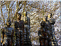
Steel Columns (sculpture detail) in Bilston, Wolverhampton
Steel Columns (1997) by Robert Koenig is made from fifteen lengths of sweet chestnut up to six metres in height. They refer to Bilston's steel making background. The figures are based on old Victorian photographs.
There are nineteen Black Country Route sculptures by nineteen different artists. These varied works reflect both the area’s heritage and its promise for the future. This one can be seen by Oxford Street near the roundabout.
Image: © Roger D Kidd
Taken: 10 Nov 2017
0.03 miles