IMAGES TAKEN NEAR TO
Darlaston Lane, BILSTON, WV14 7BL
Introduction
This page details the photographs taken nearby to Darlaston Lane, WV14 7BL by members of the Geograph project.
The Geograph project started in 2005 with the aim of publishing, organising and preserving representative images for every square kilometre of Great Britain, Ireland and the Isle of Man.

There are currently over 7.5m images from over14,400 individuals and you can help contribute to the project by visiting https://www.geograph.org.uk
Image Map
Images are licensed for reuse under creativecommons.org/licenses/by-sa/2.0
Notes
- Clicking on the map will re-center to the selected point.
- The higher the marker number, the further away the image location is from the centre of the postcode.
Image Listing (40 Images Found)
Images are licensed for reuse under creativecommons.org/licenses/by-sa/2.0
Image
Details
Distance
1
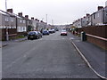
Bickley Road
The view off Darlaston Lane on to the Lunt Estate, Bilston.
Image: © Gordon Griffiths
Taken: 1 Nov 2010
0.03 miles
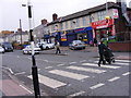
2
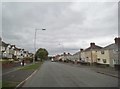
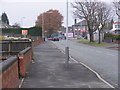
Darlaston Lane
The view along the Bilston lane.
Image: © Gordon Griffiths
Taken: 27 Sep 2016
0.04 miles
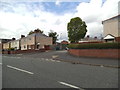
4
Wrenbury Drive
The drive off Darlaston Lane looks on to open land along side the Black Country Route, Bilston.
Image: © Gordon Griffiths
Taken: 1 Nov 2010
0.08 miles
5
The Lunt Shops
The view in Lunt Road on the Lunt Estate, Bilston.
Image: © Gordon Griffiths
Taken: 1 Nov 2010
0.09 miles
6
Addison Place
The view off Lunt Street, Bilston.
Image: © Gordon Griffiths
Taken: 22 May 2014
0.11 miles
7
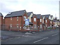
Social Housing - Lunt Road
A new development of twelve properties for the Heantun Housing Association.
Image: © John M
Taken: 21 Nov 2010
0.11 miles
8
St Thomas More RC College
This school has moved from an adjacent site on Bilston Road into new premises.
Image: © John M
Taken: 23 Sep 2006
0.12 miles
9
Darlaston Lane Lights
The Traffic lights mark the junction with Bilston Road.
Image: © Gordon Griffiths
Taken: 1 Nov 2010
0.12 miles
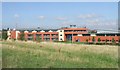
10
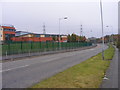
St Thomas More View
The view of Darlaston Lane next to the secondary school. The Black Country Route Bridge can be seen in the distance.
Image: © Gordon Griffiths
Taken: 1 Nov 2010
0.12 miles