IMAGES TAKEN NEAR TO
Castlecroft Road, BILSTON, WV14 6PQ
Introduction
This page details the photographs taken nearby to Castlecroft Road, WV14 6PQ by members of the Geograph project.
The Geograph project started in 2005 with the aim of publishing, organising and preserving representative images for every square kilometre of Great Britain, Ireland and the Isle of Man.

There are currently over 7.5m images from over14,400 individuals and you can help contribute to the project by visiting https://www.geograph.org.uk
Image Map
Images are licensed for reuse under creativecommons.org/licenses/by-sa/2.0
Notes
- Clicking on the map will re-center to the selected point.
- The higher the marker number, the further away the image location is from the centre of the postcode.
Image Listing (72 Images Found)
Images are licensed for reuse under creativecommons.org/licenses/by-sa/2.0
Image
Details
Distance
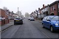
1
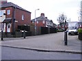
Hazel Grove
The view down the Close from Clarence Road in Bilston.
Image: © Gordon Griffiths
Taken: 20 Mar 2012
0.03 miles
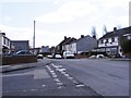
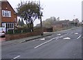
2
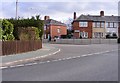
Castlecroft Road Junction
The junction with Clarence Road in Bilston.
Image: © Gordon Griffiths
Taken: 9 Mar 2012
0.03 miles
3
Castlecroft Road View
The view down Bunker's Hill Lane on St Chad's Estate, Bilston.
Image: © Gordon Griffiths
Taken: 16 Mar 2012
0.04 miles
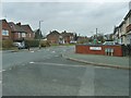
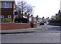
4
Clarence Road Scene
The view from the junction with Castlecroft Road and Clarence Road in Bilston.
Image: © Gordon Griffiths
Taken: 20 Mar 2012
0.04 miles
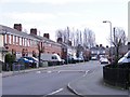
5
Bunker's Hill Lane View
The view of Bunker's Hill Lane from Castlecroft Road Bilston.
Image: © Gordon Griffiths
Taken: 20 Mar 2012
0.05 miles
6
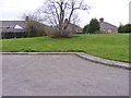
Denville Close Green
The view in the Bilston Close off Bunker's Hill Lane.
Image: © Gordon Griffiths
Taken: 16 Mar 2012
0.07 miles
7
Clarence Road View
The view on St Chad's Estate Bilston from Bunker's Hill Lane.
Image: © Gordon Griffiths
Taken: 25 Mar 2012
0.07 miles
8
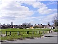
Cedar Grove
The view of the Green off the Bilston Close on the St Chad's Estate.
Image: © Gordon Griffiths
Taken: 20 Mar 2012
0.07 miles
9
Bunker's Hill Lane
The view Bunkers Hill Lane Bilston, the waste land next to the house was the Borough Arms Pub. Image
Image: © Gordon Griffiths
Taken: 1 Nov 2010
0.07 miles
10
Bunker's Hill Lane View
The view of the Bilston Street near Mount Pleasant.
Image: © Gordon Griffiths
Taken: 1 Nov 2010
0.09 miles