IMAGES TAKEN NEAR TO
Acton Grove, BILSTON, WV14 0UU
Introduction
This page details the photographs taken nearby to Acton Grove, WV14 0UU by members of the Geograph project.
The Geograph project started in 2005 with the aim of publishing, organising and preserving representative images for every square kilometre of Great Britain, Ireland and the Isle of Man.

There are currently over 7.5m images from over14,400 individuals and you can help contribute to the project by visiting https://www.geograph.org.uk
Image Map
Images are licensed for reuse under creativecommons.org/licenses/by-sa/2.0
Notes
- Clicking on the map will re-center to the selected point.
- The higher the marker number, the further away the image location is from the centre of the postcode.
Image Listing (134 Images Found)
Images are licensed for reuse under creativecommons.org/licenses/by-sa/2.0
Image
Details
Distance
1
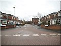
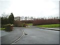
Acton Grove
The view of the close from Harley Drive in Millfields, Bilston. The land was the former Bilston Steel Works of Stewarts & Lloyds which was demolished in 1980 and the site was redeveloped for housing.
Image: © Gordon Griffiths
Taken: 31 Dec 2013
0.02 miles
2
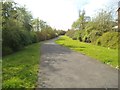
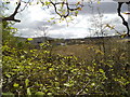
Spring Vale Path
The view of the path in Millfields, Bilston. The land was the former Bilston Steel Works of Stewarts & Lloyds which was demolished in 1980 and the site was redeveloped for housing and a business park.
Image: © Gordon Griffiths
Taken: 11 Apr 2014
0.04 miles
3
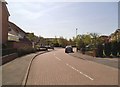
Lydham Close
The view from Harley Drive in Millfields, Bilston. The land was the former Bilston Steel Works of Stewarts & Lloyds which was demolished in 1980 and the site was redeveloped for housing.
Image: © Gordon Griffiths
Taken: 15 Apr 2014
0.04 miles
4
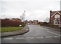
Weston Drive
The view from Harley Drive in Millfields, Bilston. The land was the former Bilston Steel Works of Stewarts & Lloyds which was demolished in 1980 and the site was redeveloped for housing.
Image: © Gordon Griffiths
Taken: 31 Dec 2013
0.05 miles
5
Harley Drive View
The view in Millfields Bilston near the Birmingham Canal. The land was the former Bilston Steel Works of Stewarts & Lloyds which was demolished in 1980 and the site was redeveloped for housing.
Image: © Gordon Griffiths
Taken: 31 Dec 2013
0.06 miles
6
Path View
The view from the path in Millfields, Bilston. The land was the former Bilston Steel Works of Stewarts & Lloyds which was demolished in 1980 and the site was redeveloped for housing and the Springvale Business Park,
Image: © Gordon Griffiths
Taken: 8 Apr 2014
0.06 miles
7
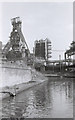
Bilston Blast Furnace 1978
This furnace was known as Elizabeth ("Big Lizzy") and had just been shut down when this photo was taken in April 1978. It closed permanently a year later.
There is a history of the steel works on the 'History of Wolverhampton' website http://www.wolverhamptonhistory.org.uk/work/industry/steel .
Image: © Guy Butler-Madden
Taken: Unknown
0.07 miles
8
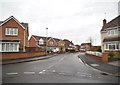
Harley Drive
The view from Weston Drive in Millfields, Bilston. The land was the former Bilston Steel Works of Stewarts & Lloyds which was demolished in 1980 and the site was redeveloped for housing.
Image: © Gordon Griffiths
Taken: 31 Dec 2013
0.07 miles
9
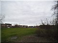
Rushbury Close View
The view of the open space in Millfields, Bilston. The land was the former Bilston Steel Works of Stewarts & Lloyds which was demolished in 1980 and the site was redeveloped for housing.
Image: © Gordon Griffiths
Taken: 31 Dec 2013
0.07 miles
10
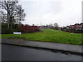
Weston Drive
The view of the open space in Millfields, Bilston. The land was the former Bilston Steel Works of Stewarts & Lloyds which was demolished in 1980 and the site was redeveloped for housing.
Image: © Gordon Griffiths
Taken: 10 Feb 2025
0.08 miles