IMAGES TAKEN NEAR TO
Union Street, BILSTON, WV14 0QT
Introduction
This page details the photographs taken nearby to Union Street, WV14 0QT by members of the Geograph project.
The Geograph project started in 2005 with the aim of publishing, organising and preserving representative images for every square kilometre of Great Britain, Ireland and the Isle of Man.

There are currently over 7.5m images from over14,400 individuals and you can help contribute to the project by visiting https://www.geograph.org.uk
Image Map
Images are licensed for reuse under creativecommons.org/licenses/by-sa/2.0
Notes
- Clicking on the map will re-center to the selected point.
- The higher the marker number, the further away the image location is from the centre of the postcode.
Image Listing (212 Images Found)
Images are licensed for reuse under creativecommons.org/licenses/by-sa/2.0
Image
Details
Distance
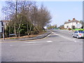
1
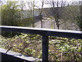
Bridge View
The view from Millfields Road (A4039) in Bilston down the former railway line.
Image: © Gordon Griffiths
Taken: 18 Apr 2010
0.03 miles
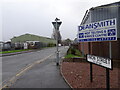
2
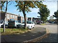
Springvale Industrial Park
The view of Union Street.
Image: © Gordon Griffiths
Taken: 17 Oct 2008
0.04 miles
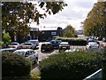
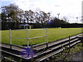
4
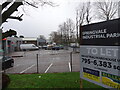
Springvale Park
The view of the Industrial Estate from Millfields Road (A4039) in Bilston.
Image: © Gordon Griffiths
Taken: 2 Dec 2020
0.05 miles
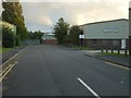
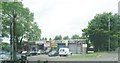
5
Union Street View
The view up Millfields Road (A4039) in Bilston.
Image: © Gordon Griffiths
Taken: 18 Apr 2010
0.05 miles
6
Union Street Scene
The view from the Millfields Road (A4039) in Bilston.
Image: © Gordon Griffiths
Taken: 2 Dec 2020
0.05 miles
8
Union Street Scene
The from Millfields Road in Bilston.
Image: © Gordon Griffiths
Taken: 4 Jun 2019
0.06 miles
10
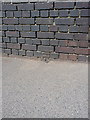
OS benchmark - Millfields Road railway bridge
Cutmark in the brickwork of the railway bridge parapet on the north side of the road. The OS historical description of it states that it's about a foot above ground level. As you can see, resurfacing of the footpath means that the ground level must have crept upwards since it was originally cut. Levelled at a height of 14146.8496m, 481'9" above Ordnance Datum Newlyn.
Image: © Richard Law
Taken: 2 Aug 2013
0.06 miles