IMAGES TAKEN NEAR TO
Albion Street, WOLVERHAMPTON, WV1 3EJ
Introduction
This page details the photographs taken nearby to Albion Street, WV1 3EJ by members of the Geograph project.
The Geograph project started in 2005 with the aim of publishing, organising and preserving representative images for every square kilometre of Great Britain, Ireland and the Isle of Man.

There are currently over 7.5m images from over14,400 individuals and you can help contribute to the project by visiting https://www.geograph.org.uk
Image Map
Images are licensed for reuse under creativecommons.org/licenses/by-sa/2.0
Notes
- Clicking on the map will re-center to the selected point.
- The higher the marker number, the further away the image location is from the centre of the postcode.
Image Listing (867 Images Found)
Images are licensed for reuse under creativecommons.org/licenses/by-sa/2.0
Image
Details
Distance
1
Steps to Mill
A path runs between the Corn Hill Apartments to the Converted Albion Mill.
Image: © Gordon Griffiths
Taken: 16 Aug 2008
0.01 miles
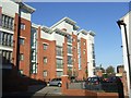
2
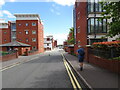
Albion Street
The view in Wolverhampton.
Image: © Gordon Griffiths
Taken: 27 Jun 2022
0.02 miles
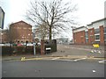
3
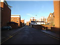
Albion Street Scene
The view in Horseley Fields, Wolverhampton.
Image: © Gordon Griffiths
Taken: 10 Nov 2013
0.02 miles
4
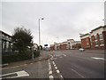
Horseley Fields Junction
The view of the A454 in Horseley Fields, Wolverhampton.
Image: © Gordon Griffiths
Taken: 15 Oct 2013
0.02 miles
5
Warehouses beside the Birmingham Canal, Wolverhampton Level
Image: © JThomas
Taken: 5 Oct 2013
0.04 miles
6
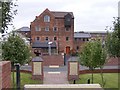
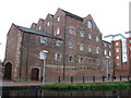
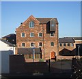
Albion Mill, Horseley Fields
The left-hand part seen here was built around 1830 as a grain trans-shipment facility (ie loading on and off canal barges) whilst the right-hand section is a little later in the 19th century. It backs onto the canal Image and once had its own canal basin & spur and associated barge loading gear, but the canal inlet has now been blocked off, and the whole place is converted to flats. Grade II listed https://britishlistedbuildings.co.uk/101201771-albion-mill-heath-town-ward#.Y3zeo3bP3IU & https://historicengland.org.uk/listing/the-list/list-entry/1201771 in 1989
Image: © Richard Law
Taken: 4 Jul 2022
0.04 miles
7
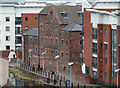
Former Mill, Albion Street, Wolverhampton
This is Albion Mill, a grade II listed mid-1830s corn mill with later extensions. It is immersed in recent developments along the canal. Seen from the top of the station car park. Multi-storey car parks are great vantage points but the modern trend to make it difficult to see from the top is to be deprecated.
Image: © Chris Allen
Taken: 7 Apr 2013
0.04 miles
8
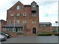
Albion Mill on Albion Street
An 1830s Corn Mill, this Grade II listed building has been converted into apartments. For pre-conversion see http://www.localhistory.scit.wlv.ac.uk/listed/albionmill.htm
Image: © John M
Taken: 4 Nov 2006
0.04 miles
9
Apartments in Corn Hill
A new development next to the canal packs the housing in tight with minimal green space or parking. I was stuck for ages in a narrow access road following the bin lorry!
Image: © John M
Taken: 4 Nov 2006
0.04 miles
10
Gough Street View
The view of the road near Wolverhampton railway station's new car park.
Image: © Gordon Griffiths
Taken: 26 Jan 2017
0.04 miles