IMAGES TAKEN NEAR TO
Albion Street, WOLVERHAMPTON, WV1 3EG
Introduction
This page details the photographs taken nearby to Albion Street, WV1 3EG by members of the Geograph project.
The Geograph project started in 2005 with the aim of publishing, organising and preserving representative images for every square kilometre of Great Britain, Ireland and the Isle of Man.

There are currently over 7.5m images from over14,400 individuals and you can help contribute to the project by visiting https://www.geograph.org.uk
Image Map
Images are licensed for reuse under creativecommons.org/licenses/by-sa/2.0
Notes
- Clicking on the map will re-center to the selected point.
- The higher the marker number, the further away the image location is from the centre of the postcode.
Image Listing (704 Images Found)
Images are licensed for reuse under creativecommons.org/licenses/by-sa/2.0
Image
Details
Distance
1
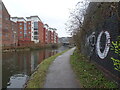
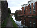
Canalside View
The Birmingham Canal passes through Wolverhampton. The Corn Hill apartments on the left.
Image: © Gordon Griffiths
Taken: 10 Feb 2025
0.01 miles
2
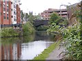
City Canal
The Birmingham Canal passes through Wolverhampton.The Corn Hill apartments on the Left, St Peters Church in the centre and the Railway Station multistorey Carpark to the right.
Image: © Gordon Griffiths
Taken: 16 Aug 2008
0.01 miles
3
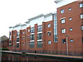
New apartments, Birmingham Canal, Wolverhampton Level
Image: © JThomas
Taken: 5 Oct 2013
0.01 miles
4
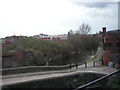
New housing and old buildings, off Albion Street
On [or very near] the site of the BCN's Albion Basin and Albion Wharf.
Image: © Christine Johnstone
Taken: 7 May 2018
0.01 miles
6

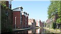
Housing developments alongside the canal
The new flats crowd and dwarf the old Albion Mill building along the side of the canal, just on the outskirts of the centre of Wolverhampton.
Image: © Richard Law
Taken: 22 Oct 2008
0.01 miles
8

Albion Mill and new flats beside the canal
Image: © Richard Law
Taken: 22 Oct 2008
0.02 miles
9
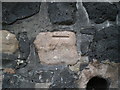
OS benchmark - Wolverhampton, canalside wall
An OS cutmark on the sandstone & slag rubble wall on the north side of the canal; originally levelled at 144.893m above Ordnance Datum Newlyn, probably in 1957.
Image: © Richard Law
Taken: 26 Oct 2016
0.02 miles
10
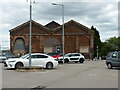
The Mill Street Depot, Corn Hill, Wolverhampton
A former railway goods depot, built in the mid 19th century (around 1850) for the Shrewsbury and Birmingham Railway and London and North Western Railway Companies. Here we are looking 'end-on' at the building, which is much more extensive than this photo suggests, and it is described in its 1992 Grade II listing https://britishlistedbuildings.co.uk/101201805-mill-street-depot-heath-town-ward#.Y36FFHbP3IU & https://historicengland.org.uk/listing/the-list/list-entry/1201805 as "A good and well-preserved example of an early railway goods depot." Many original internal features are apparently still in place.
Image: © Richard Law
Taken: 4 Jul 2022
0.03 miles