IMAGES TAKEN NEAR TO
Union Mill Street, WOLVERHAMPTON, WV1 3DW
Introduction
This page details the photographs taken nearby to Union Mill Street, WV1 3DW by members of the Geograph project.
The Geograph project started in 2005 with the aim of publishing, organising and preserving representative images for every square kilometre of Great Britain, Ireland and the Isle of Man.

There are currently over 7.5m images from over14,400 individuals and you can help contribute to the project by visiting https://www.geograph.org.uk
Image Map
Images are licensed for reuse under creativecommons.org/licenses/by-sa/2.0
Notes
- Clicking on the map will re-center to the selected point.
- The higher the marker number, the further away the image location is from the centre of the postcode.
Image Listing (540 Images Found)
Images are licensed for reuse under creativecommons.org/licenses/by-sa/2.0
Image
Details
Distance
1
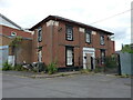
16a Union Mill Street, Horseley Fields
Former offices to the adjoining (and now also derelict) Cheese & Butter warehouse which were built in the early 19th century. The building was certainly still in use in 2001 as the offices of a business called Air Control Products, but is now empty and, sadly, deteriorating. It was Grade II listed https://britishlistedbuildings.co.uk/101201884-16a-union-mill-street-heath-town-ward#.Y30JmnbP3IU & https://historicengland.org.uk/listing/the-list/list-entry/1201884 in 1977.
Image: © Richard Law
Taken: 4 Jul 2022
0.00 miles
2
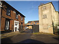
Union Mill Street
The view in Horseley Fields, Wolverhampton.
Image: © Gordon Griffiths
Taken: 10 Nov 2013
0.00 miles
3
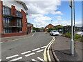
Albion Street View
The view in Wolverhampton.
Image: © Gordon Griffiths
Taken: 27 Jun 2022
0.02 miles
4
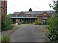
Former butter & cheese warehouse, Horseley Fields
More or less immediately to the north of its one-time offices Image, this warehouse dates from the same period in the early 19th century, and was originally used as a dairy products store and distribution centre. More recently it has served for other light industrial purposes, but is clearly empty and becoming rather derelict at the time of this photo. Grade II listed https://britishlistedbuildings.co.uk/101208651-former-cheese-and-butter-warehouse-approximately-20-meters-north-of-no-16a-heath-town-ward#.Y36B3nbP3IU & https://historicengland.org.uk/listing/the-list/list-entry/1208651 in 1988.
Image: © Richard Law
Taken: 4 Jul 2022
0.02 miles
5
Albion Street
The view in Horseley Fields, Wolverhampton.
Image: © Gordon Griffiths
Taken: 10 Nov 2013
0.03 miles
6
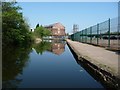
Birmingham Canal, approaching central Wolverhampton
This is the Wolverhampton level, on the 473ft contour.
Image: © Christine Johnstone
Taken: 7 May 2018
0.03 miles
7
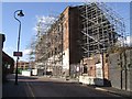
Scaffolding - Corn Hill
So this is why the road has been closed for months. If this were not a Grade II listed building it would have been demolished as unsafe years ago.
Image: © John M
Taken: 6 Nov 2010
0.04 miles
9
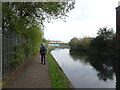
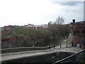
Towpath Scene
The view on the Birmingham at Horseley Fields, Wolverhampton.
Image: © Gordon Griffiths
Taken: 16 Oct 2023
0.04 miles
10

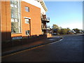
Housing developments alongside the canal
The new flats crowd and dwarf the old Albion Mill building along the side of the canal, just on the outskirts of the centre of Wolverhampton.
Image: © Richard Law
Taken: 22 Oct 2008
0.04 miles