IMAGES TAKEN NEAR TO
Horseley Field, WOLVERHAMPTON, WV1 3DG
Introduction
This page details the photographs taken nearby to Horseley Field, WV1 3DG by members of the Geograph project.
The Geograph project started in 2005 with the aim of publishing, organising and preserving representative images for every square kilometre of Great Britain, Ireland and the Isle of Man.

There are currently over 7.5m images from over14,400 individuals and you can help contribute to the project by visiting https://www.geograph.org.uk
Image Map
Images are licensed for reuse under creativecommons.org/licenses/by-sa/2.0
Notes
- Clicking on the map will re-center to the selected point.
- The higher the marker number, the further away the image location is from the centre of the postcode.
Image Listing (493 Images Found)
Images are licensed for reuse under creativecommons.org/licenses/by-sa/2.0
Image
Details
Distance
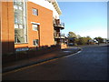
1
Ward Street
The view in Horseley Fields, Wolverhampton.
Image: © Gordon Griffiths
Taken: 15 Oct 2013
0.02 miles
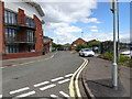
2
Horseley Fields
The view from Shakespeare Street in Horseley Fields, Wolverhampton.
Image: © Gordon Griffiths
Taken: 15 Oct 2013
0.04 miles
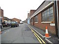
3
Shakespeare Street
The view in Horseley Fields, Wolverhampton.
Image: © Gordon Griffiths
Taken: 15 Oct 2013
0.04 miles
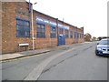
4
Telephone Exchange, Horseley Fields
This TE, which seems to have been rebuilt quite recently, is located in Horseley Fields, near Union Mill Street, just East of Wolverhampton City Centre. Its postcode is WV1 3DW. Interestingly enough, there is a photograph of its GPO predecessor on page 60 of the 2004 book "A Nostalgic Tour of Wolverhampton by Tram, Trolleybus and Bus: Part 3 The Eastern Routes". Unfortunately, the bus pictured in front of that TE saw only a few years service in Wolverhampton, whereas that TE is still there, having been rebuilt in the meantime, and the Strowger equipment inside it replaced by the digital System X equipment.
Image: © David Hillas
Taken: 9 Sep 2009
0.04 miles
5
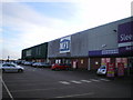
MFI - closed down but not completely gone away
The premises of MFI in Wolverhampton, which closed late in 2008/early 2009. The signage has not yet been removed, and probably won't be until someone else takes the unit on.
Image: © Richard Law
Taken: 16 Jan 2009
0.05 miles
6
Albion Street View
The view in Wolverhampton.
Image: © Gordon Griffiths
Taken: 27 Jun 2022
0.06 miles
7
Albion Street
The view in Horseley Fields, Wolverhampton.
Image: © Gordon Griffiths
Taken: 10 Nov 2013
0.06 miles
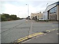
8
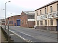
Walsall Street
The view from Commercial Road in Horseley Fields, Wolverhampton.
Image: © Gordon Griffiths
Taken: 15 Oct 2013
0.06 miles
9
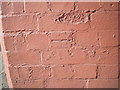
OS benchmark - Wolverhampton, Walsall Street
An OS cutmark, pointed up with mortar, on the corner of a factory building on Walsall Street. It was originally levelled at 148.377m above Ordnance Datum Newlyn.
Image: © Richard Law
Taken: 10 May 2017
0.07 miles
10
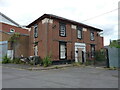
16a Union Mill Street, Horseley Fields
Former offices to the adjoining (and now also derelict) Cheese & Butter warehouse which were built in the early 19th century. The building was certainly still in use in 2001 as the offices of a business called Air Control Products, but is now empty and, sadly, deteriorating. It was Grade II listed https://britishlistedbuildings.co.uk/101201884-16a-union-mill-street-heath-town-ward#.Y30JmnbP3IU & https://historicengland.org.uk/listing/the-list/list-entry/1201884 in 1977.
Image: © Richard Law
Taken: 4 Jul 2022
0.07 miles