IMAGES TAKEN NEAR TO
East Street, WOLVERHAMPTON, WV1 3BE
Introduction
This page details the photographs taken nearby to East Street, WV1 3BE by members of the Geograph project.
The Geograph project started in 2005 with the aim of publishing, organising and preserving representative images for every square kilometre of Great Britain, Ireland and the Isle of Man.

There are currently over 7.5m images from over14,400 individuals and you can help contribute to the project by visiting https://www.geograph.org.uk
Image Map
Images are licensed for reuse under creativecommons.org/licenses/by-sa/2.0
Notes
- Clicking on the map will re-center to the selected point.
- The higher the marker number, the further away the image location is from the centre of the postcode.
Image Listing (333 Images Found)
Images are licensed for reuse under creativecommons.org/licenses/by-sa/2.0
Image
Details
Distance
1
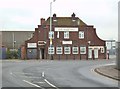
The Harp Inn
The view from Commercial Road in Horseley Fields, Wolverhampton.
Image: © Gordon Griffiths
Taken: 15 Oct 2013
0.03 miles
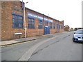
2
Wharf Street
The view from Commercial Road in Horseley Fields, Wolverhampton.
Image: © Gordon Griffiths
Taken: 15 Oct 2013
0.03 miles
3
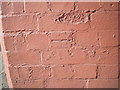
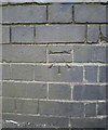
OS benchmark - Wolverhampton, Walsall Street
An OS cutmark, pointed up with mortar, on the corner of a factory building on Walsall Street. It was originally levelled at 148.377m above Ordnance Datum Newlyn.
Image: © Richard Law
Taken: 10 May 2017
0.03 miles
4
Walsall Street
The view from Commercial Road in Horseley Fields, Wolverhampton.
Image: © Gordon Griffiths
Taken: 15 Oct 2013
0.05 miles
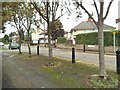
5
Shakespeare Street
The view in Horseley Fields, Wolverhampton.
Image: © Gordon Griffiths
Taken: 15 Oct 2013
0.06 miles
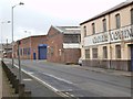
6
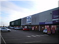
MFI - closed down but not completely gone away
The premises of MFI in Wolverhampton, which closed late in 2008/early 2009. The signage has not yet been removed, and probably won't be until someone else takes the unit on.
Image: © Richard Law
Taken: 16 Jan 2009
0.06 miles
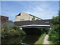
7
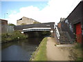
Lower Walsall Street Bridge
The view of the Birmingham Canal in Horseley Fields, Wolverhampton.
Image: © Gordon Griffiths
Taken: 6 Aug 2014
0.08 miles
9
OS benchmark - Wolverhampton, Lower Walsall St canal bridge
An OS cutmark on the roadside parapet of the canal bridge; originally levelled at 147.651m above Ordnance Datum Newlyn, and most likely cut in 1957.
Image: © Richard Law
Taken: 12 Sep 2016
0.08 miles
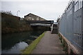
10
Walsall Street Bridge
Over the Birmingham Canal.
Image: © John M
Taken: 26 Jul 2008
0.08 miles