IMAGES TAKEN NEAR TO
Evans Street, WILLENHALL, WV13 3UN
Introduction
This page details the photographs taken nearby to Evans Street, WV13 3UN by members of the Geograph project.
The Geograph project started in 2005 with the aim of publishing, organising and preserving representative images for every square kilometre of Great Britain, Ireland and the Isle of Man.

There are currently over 7.5m images from over14,400 individuals and you can help contribute to the project by visiting https://www.geograph.org.uk
Image Map
Images are licensed for reuse under creativecommons.org/licenses/by-sa/2.0
Notes
- Clicking on the map will re-center to the selected point.
- The higher the marker number, the further away the image location is from the centre of the postcode.
Image Listing (19 Images Found)
Images are licensed for reuse under creativecommons.org/licenses/by-sa/2.0
Image
Details
Distance
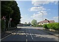
1
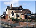
The Neachells Public House
Pub next to a busy junction on the Wolverhampton to Willenhall and Walsall road.
Image: © John M
Taken: 23 Sep 2006
0.08 miles
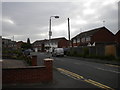
3
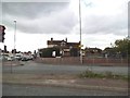
The Neachells
The view of the former Pub on Neachells Lane, Wolverhampton. The Pub in 2006.Image
Image: © Gordon Griffiths
Taken: 6 May 2014
0.11 miles
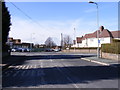
4
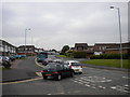
Evening peak traffic, Moseley Road, Portobello
At around half past five on a Wednesday afternoon, traffic queues along Moseley Road from its junction with the A454 Willenhall Road.
Image: © Richard Vince
Taken: 5 Jun 2013
0.15 miles
5
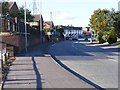
Hill Road Junction
The junction with Vaughan Road in Portobello, Bilston.
Image: © Gordon Griffiths
Taken: 20 Apr 2022
0.18 miles
6
Alcester Drive, Portobello
A residential cul de sac off Moseley Road, close to the north eastern corner of Stowlawn estate (some of whose flats are visible on the left; see Image).
Image: © Richard Vince
Taken: 5 Jun 2013
0.18 miles
7
Vaughan Road Junction
The junction with Hill Road in Portobello, Bilston.
Image: © Gordon Griffiths
Taken: 6 Mar 2012
0.18 miles
8
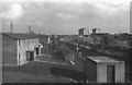
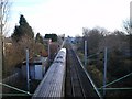
View of the Grand Junction line from Neachells Lane Bridge, looking towards Noose Lane Level Crossing and Willenhall
View of the Grand Junction line from Neachells Lane Bridge, looking towards Noose Lane Level Crossing and Willenhall. 1978. The houses on the left had recently been built on waste ground that we always knew as "Noose Lane Banks". In 1974 there was an derailment at this point, which partially demolished the signal box protecting Noose Lane. After completion of the demolition a temporary gate keepers structure was erected (just visible in the photograph) and modern barriers replaced the old level crossing gates.
Image: © Tim Marshall
Taken: 23 Oct 1978
0.18 miles
9
Grand Junction Line at Moseley Village
The Wrexham and Shropshire Company train is heading out of the Wolverhampton area towards London.
Image: © Richard Law
Taken: 20 Jan 2009
0.19 miles
10
Moseley Road Lights
The crossing near to Stowlawn Estate, Bilston.
Image: © Gordon Griffiths
Taken: 20 Oct 2010
0.19 miles