IMAGES TAKEN NEAR TO
Willenhall Road, WILLENHALL, WV13 3PS
Introduction
This page details the photographs taken nearby to Willenhall Road, WV13 3PS by members of the Geograph project.
The Geograph project started in 2005 with the aim of publishing, organising and preserving representative images for every square kilometre of Great Britain, Ireland and the Isle of Man.

There are currently over 7.5m images from over14,400 individuals and you can help contribute to the project by visiting https://www.geograph.org.uk
Image Map
Images are licensed for reuse under creativecommons.org/licenses/by-sa/2.0
Notes
- Clicking on the map will re-center to the selected point.
- The higher the marker number, the further away the image location is from the centre of the postcode.
Image Listing (22 Images Found)
Images are licensed for reuse under creativecommons.org/licenses/by-sa/2.0
Image
Details
Distance
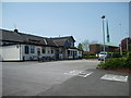
1
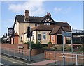
The Neachells Public House
Pub next to a busy junction on the Wolverhampton to Willenhall and Walsall road.
Image: © John M
Taken: 23 Sep 2006
0.04 miles
2
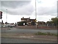
The Neachells
The view of the former Pub on Neachells Lane, Wolverhampton. The Pub in 2006.Image
Image: © Gordon Griffiths
Taken: 6 May 2014
0.06 miles
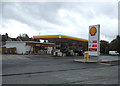
4
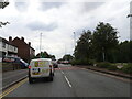
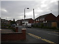
Willenhall Road
The view along the Willenhall Road A454 in Wolverhampton.
Image: © Gordon Griffiths
Taken: 29 Jul 2022
0.13 miles
5
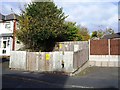
Electricity sub station, Marshall Road
Image: © Alex McGregor
Taken: 8 Nov 2012
0.15 miles
6
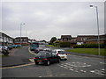
Evening peak traffic, Moseley Road, Portobello
At around half past five on a Wednesday afternoon, traffic queues along Moseley Road from its junction with the A454 Willenhall Road.
Image: © Richard Vince
Taken: 5 Jun 2013
0.18 miles
8
The Cleveland Arms
This pub stands on the junction of the Willenhall Road and Stow Heath Lane. The church in the background is St. John's.
Image: © Gordon Griffiths
Taken: 28 Apr 2007
0.19 miles
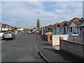
9
Alcester Drive, Portobello
A residential cul de sac off Moseley Road, close to the north eastern corner of Stowlawn estate (some of whose flats are visible on the left; see Image).
Image: © Richard Vince
Taken: 5 Jun 2013
0.20 miles
10
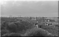
View of Portobello Junction on the old Grand Junction line from the Neachells Lane Road Bridge.
View of Portobello Junction on the former Grand Junction line taken from the Neachells Lane Road Bridge. 1978. The lines to left lead towards Wolverhampton High Level Station whilst those going straight on lead to Wednesfield Heath and Busbury Junction.
On October 19th 1899 the 5.50.am. train from Wolverhampton to London collided with a freight train at Portobello Junction in thick fog, cutting the freight train in half, causing much damage to the track and resulting in the death of the driver and fireman of the passenger train. Goods were scattered all over the embankment and the line was closed to traffic for several days.There were 25 passengers on the London bound train but fortunately none were injured. There was a further accident in 1974, slightly to the south of this point but fortunately without fatalities.
Image: © Tim Marshall
Taken: 23 Oct 1978
0.21 miles