IMAGES TAKEN NEAR TO
Swan Place, WILLENHALL, WV13 3BF
Introduction
This page details the photographs taken nearby to Swan Place, WV13 3BF by members of the Geograph project.
The Geograph project started in 2005 with the aim of publishing, organising and preserving representative images for every square kilometre of Great Britain, Ireland and the Isle of Man.

There are currently over 7.5m images from over14,400 individuals and you can help contribute to the project by visiting https://www.geograph.org.uk
Image Map
Images are licensed for reuse under creativecommons.org/licenses/by-sa/2.0
Notes
- Clicking on the map will re-center to the selected point.
- The higher the marker number, the further away the image location is from the centre of the postcode.
Image Listing (25 Images Found)
Images are licensed for reuse under creativecommons.org/licenses/by-sa/2.0
Image
Details
Distance
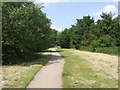
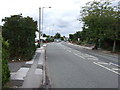
1
Path west of Fibbersley Bridge, Little London
Along the alignment of the long closed Bentley Canal.
Image: © Richard Vince
Taken: 20 Oct 2018
0.01 miles
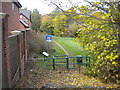
2
Fibbersley Local Nature Reserve
This was declared as a nature reserve in 1999. The site was formerly occupied by deep coal mines dating from the 19th century, clay pits, railways and the Bentley Canal. All of these have been abandoned and the much scarred site has reverted to nature leaving an important wetland habitat of pools, meadows and woodland.
This access point is on the line of the Bentley Canal, closed in the 1950s.
Image: © John M
Taken: 7 Jun 2008
0.01 miles
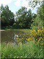
3

Pool - Fibbersley Local Nature Reserve
The wetland habitat is an important breeding ground for newts and amphibians. As with most urban sites there is the odd traffic cone or shopping trolley to be removed.
Image: © John M
Taken: 7 Jun 2008
0.04 miles
4
Pool - Fibbersley Local Nature Reserve
Possibly a former canal basin on the Bentley Canal, closed in the 1950s, now reverted to nature.
Image: © John M
Taken: 7 Jun 2008
0.05 miles
5
Bentley Canal - Fibbersley Local Nature Reserve
The line of the canal towards Wednesfield and Wolverhampton. When opened in 1843 it would have served the collieries and clay pits. The canal closed in the 1960s.
Image: © John M
Taken: 7 Jun 2008
0.05 miles
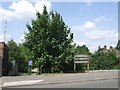
6
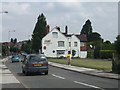
Navigation Inn, Fibbersley
The Bentley Canal is a fading memory closed in the 1950s: all that remains is the pub name. The canal opened in 1843 to service the local collieries and clay pits.
Image: © John M
Taken: 7 Jun 2008
0.05 miles
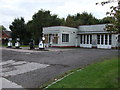
10
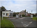
Disused petrol station, Little London
Off Fibbersley at its junction with Noose Lane.
Image: © Richard Vince
Taken: 20 Oct 2018
0.11 miles