IMAGES TAKEN NEAR TO
Crescent Road, WILLENHALL, WV13 2RB
Introduction
This page details the photographs taken nearby to Crescent Road, WV13 2RB by members of the Geograph project.
The Geograph project started in 2005 with the aim of publishing, organising and preserving representative images for every square kilometre of Great Britain, Ireland and the Isle of Man.

There are currently over 7.5m images from over14,400 individuals and you can help contribute to the project by visiting https://www.geograph.org.uk
Image Map
Images are licensed for reuse under creativecommons.org/licenses/by-sa/2.0
Notes
- Clicking on the map will re-center to the selected point.
- The higher the marker number, the further away the image location is from the centre of the postcode.
Image Listing (18 Images Found)
Images are licensed for reuse under creativecommons.org/licenses/by-sa/2.0
Image
Details
Distance
1
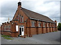
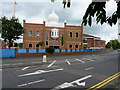
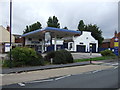
Maha Shiv Shakti Mandir
A converted Anglican church on Fletchers Lane, Willenhall, now used as a Hindu temple. http://www.mahashivshaktimandir.co.uk/
Image: © Richard Law
Taken: 7 Jul 2010
0.03 miles
2
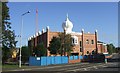
Guru Nanak Gurdwara
Recently extended Sikh temple on the Willenhall to Walsall Road.
Image: © John M
Taken: 7 Oct 2006
0.03 miles
3
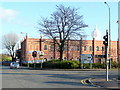
Guru Nanak Gurdwara
Sikh temple viewed from the Walsall Road across Clark's Lane, Willenhall.
Image: © Jonathan Billinger
Taken: 17 Nov 2009
0.07 miles
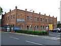
5
The Guru Nanak Gurdwara Sikh temple in Willenhall
Image: © Richard Law
Taken: 7 Jul 2010
0.08 miles
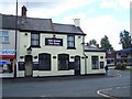
10
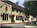
The Red Lion, Willenhall
This public house is on a very busy road.
Image: © Angella Streluk
Taken: 22 Aug 2005
0.17 miles