IMAGES TAKEN NEAR TO
St. Stephens Avenue, WILLENHALL, WV13 2PP
Introduction
This page details the photographs taken nearby to St. Stephens Avenue, WV13 2PP by members of the Geograph project.
The Geograph project started in 2005 with the aim of publishing, organising and preserving representative images for every square kilometre of Great Britain, Ireland and the Isle of Man.

There are currently over 7.5m images from over14,400 individuals and you can help contribute to the project by visiting https://www.geograph.org.uk
Image Map
Images are licensed for reuse under creativecommons.org/licenses/by-sa/2.0
Notes
- Clicking on the map will re-center to the selected point.
- The higher the marker number, the further away the image location is from the centre of the postcode.
Image Listing (59 Images Found)
Images are licensed for reuse under creativecommons.org/licenses/by-sa/2.0
Image
Details
Distance
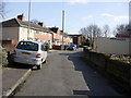
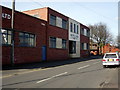
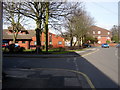
2
Round Croft Willenhall looking towards Field Street
Round Croft Willenhall showing the former works of E.Nicklin & Sons Ltd (also of Henry Ellard & Sons Ltd and the re-furbished flats in Gomer Street).
Image: © Tim Marshall
Taken: 2 Mar 2010
0.03 miles
4
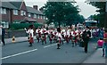
Carnival Parade, Pinson Road Willenhall, June 1990.
Willenhall Carnival used to be very popular. By 1990 things had faded a little but the parade was still worth seeing.
Image: © Tim Marshall
Taken: 16 Jun 1990
0.05 miles
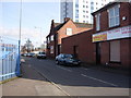
5
Former Factory, Field Street, Willenhall
Former works of E.Nicklin & Sons Ltd, Later Henry Ellard, Field Street, Willenhall. Looking in the direction of Round Croft & Croft Street.
Image: © Tim Marshall
Taken: 2 Mar 2010
0.06 miles
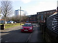
6
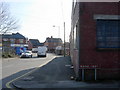
Junction of Round Croft & Field Street, Willenhall
Looking in the direction of Wolverhampton Street.
Image: © Tim Marshall
Taken: 2 Mar 2010
0.07 miles
7
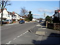
Pinson Road, Willenhall, looking towards Field Street
Taken from the Junction of Round Croft and Pinson Road looking towards Field Street and Stafford Street.
Image: © Tim Marshall
Taken: 2 Mar 2010
0.07 miles
8
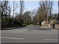
Main entrance to the Memorial Park, Pinson Road, Willenhall
Image: © Tim Marshall
Taken: 2 Mar 2010
0.08 miles
9
Junction of Round Croft & Field Street, Willenhall
Looking in the direction of Croft Street & Pinson Road
Image: © Tim Marshall
Taken: 2 Mar 2010
0.08 miles
10
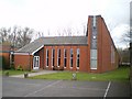
The church of St Stephen the Martyr in Willenhall
This is in Wolverhampton Street, and very, very close to the grid square boundary.
I couldn't establish what the poor chap was martyred for, but the name stands regardless.
Image: © Richard Law
Taken: 13 Mar 2009
0.08 miles