IMAGES TAKEN NEAR TO
Pinson Road, WILLENHALL, WV13 2PL
Introduction
This page details the photographs taken nearby to Pinson Road, WV13 2PL by members of the Geograph project.
The Geograph project started in 2005 with the aim of publishing, organising and preserving representative images for every square kilometre of Great Britain, Ireland and the Isle of Man.

There are currently over 7.5m images from over14,400 individuals and you can help contribute to the project by visiting https://www.geograph.org.uk
Image Map
Images are licensed for reuse under creativecommons.org/licenses/by-sa/2.0
Notes
- Clicking on the map will re-center to the selected point.
- The higher the marker number, the further away the image location is from the centre of the postcode.
Image Listing (65 Images Found)
Images are licensed for reuse under creativecommons.org/licenses/by-sa/2.0
Image
Details
Distance
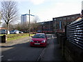
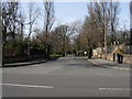
1
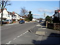
Pinson Road, Willenhall, looking towards Field Street
Taken from the Junction of Round Croft and Pinson Road looking towards Field Street and Stafford Street.
Image: © Tim Marshall
Taken: 2 Mar 2010
0.02 miles
2
Dartmouth Avenue, Willenhall.
Dartmouth Avenue, Willenhall, looking towards The Central Schools, March 1978.
Image: © Tim Marshall
Taken: Unknown
0.04 miles
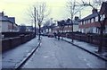
3
Junction of Round Croft & Field Street, Willenhall
Looking in the direction of Croft Street & Pinson Road
Image: © Tim Marshall
Taken: 2 Mar 2010
0.07 miles
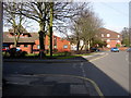
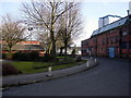
5
Round Croft Willenhall looking towards Field Street
Round Croft Willenhall showing the former works of E.Nicklin & Sons Ltd (also of Henry Ellard & Sons Ltd and the re-furbished flats in Gomer Street).
Image: © Tim Marshall
Taken: 2 Mar 2010
0.07 miles
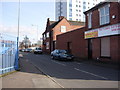
6
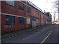
Former works of E.Nicklin & Sons, Round Croft, Willenhall.
Although they have been used by others including Henry Ellard & Sons Ltd these premises were built for E.Nicklin & Sons Ltd (est 1894) who were manufacturers of, amongst other things, bicycle cranks and stampings. The noise from the stamping machinery was quite loud!
Image: © Tim Marshall
Taken: 2 Mar 2010
0.07 miles
7
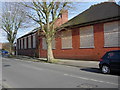
Former Central Schools buildings, Field Street, Willenhall
For a view of the playground and other buildings please see my submission http://www.geograph.org.uk/photo/1733659
Image: © Tim Marshall
Taken: 2 Mar 2010
0.07 miles
8
Willenhall Memorial Park
The park was opened in 1922 in honour of those killed in the Great War.
Image: © John M
Taken: 30 Sep 2006
0.08 miles
9
Former works of E.Nicklin & Sons Ltd, Round Croft, Willenhall
Looking in the direction of Field Street, the opposite direction to my submission http://www.geograph.org.uk/photo/1733676. On the left is a local health centre where once waste ground and a rubbish pit greeted the eye.
Image: © Tim Marshall
Taken: 2 Mar 2010
0.09 miles
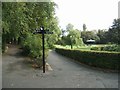
10
Main entrance to the Memorial Park, Pinson Road, Willenhall
Image: © Tim Marshall
Taken: 2 Mar 2010
0.09 miles