IMAGES TAKEN NEAR TO
New Road, WILLENHALL, WV13 2AQ
Introduction
This page details the photographs taken nearby to New Road, WV13 2AQ by members of the Geograph project.
The Geograph project started in 2005 with the aim of publishing, organising and preserving representative images for every square kilometre of Great Britain, Ireland and the Isle of Man.

There are currently over 7.5m images from over14,400 individuals and you can help contribute to the project by visiting https://www.geograph.org.uk
Image Map
Images are licensed for reuse under creativecommons.org/licenses/by-sa/2.0
Notes
- Clicking on the map will re-center to the selected point.
- The higher the marker number, the further away the image location is from the centre of the postcode.
Image Listing (81 Images Found)
Images are licensed for reuse under creativecommons.org/licenses/by-sa/2.0
Image
Details
Distance
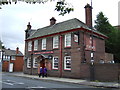
4
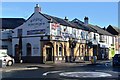
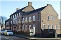
Royal George PH
This pub at the bottom of the Market Place is on a busy crossing on the old Walsall to Bilston Road. The pub was built in 1847. Ten years ago Image
Image: © John M
Taken: 10 Jan 2016
0.03 miles
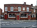
5
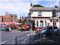
Walsall Street Junction
The Junction with Bilston Street.
Image: © Gordon Griffiths
Taken: 7 Aug 2008
0.03 miles
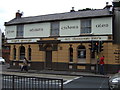
6
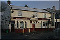
Royal George pub
The Royal George is an old pub in the centre of Willenhall.
Image: © Derek Bennett
Taken: 3 Jan 2009
0.03 miles
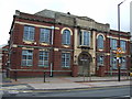
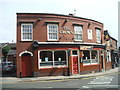
9
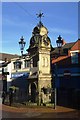
Market Cross
At the lower end of the market place.
Image: © John M
Taken: 10 Jan 2016
0.06 miles