IMAGES TAKEN NEAR TO
Monmer Close Industrial Estate, WILLENHALL, WV13 1JR
Introduction
This page details the photographs taken nearby to Monmer Close Industrial Estate, WV13 1JR by members of the Geograph project.
The Geograph project started in 2005 with the aim of publishing, organising and preserving representative images for every square kilometre of Great Britain, Ireland and the Isle of Man.

There are currently over 7.5m images from over14,400 individuals and you can help contribute to the project by visiting https://www.geograph.org.uk
Image Map
Images are licensed for reuse under creativecommons.org/licenses/by-sa/2.0
Notes
- Clicking on the map will re-center to the selected point.
- The higher the marker number, the further away the image location is from the centre of the postcode.
Image Listing (26 Images Found)
Images are licensed for reuse under creativecommons.org/licenses/by-sa/2.0
Image
Details
Distance
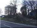
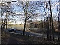
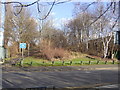
2
The former railway through Willenhall
The trackbed on this embankment has been paved into a path, but in many places around the area, the line of the railway has now been built over since its closure.
Image: © Richard Law
Taken: 24 Jun 2011
0.06 miles
3
Willenhall - Stringes Lane
Vegetation beyond the house on the right indicates the former railway embankment and junction.
Image: © Peter Whatley
Taken: 11 May 2010
0.06 miles
4
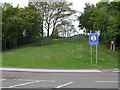
No motor sports please!
An unusual notice threatens penalties for the drivers of any vehicle caught climbing the railway embankment off Stringes Lane.
Image: © Peter Whatley
Taken: 11 May 2010
0.07 miles
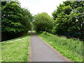
6
Disused railway embankment - Stringe's Lane
The embankment on the far side of the road has been partially removed to create a hardstanding area.
Image: © John M
Taken: 2 Feb 2013
0.09 miles
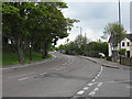
7
Willenhall - Slater Street from Stringes Lane
Image: © Peter Whatley
Taken: 11 May 2010
0.09 miles
10

St Anne Willenhall
The Church stands in St Ann Street off St Anne's Road, Willenhall.
Image: © Gordon Griffiths
Taken: 5 Mar 2009
0.14 miles