IMAGES TAKEN NEAR TO
Clarkes Lane, WILLENHALL, WV13 1JB
Introduction
This page details the photographs taken nearby to Clarkes Lane, WV13 1JB by members of the Geograph project.
The Geograph project started in 2005 with the aim of publishing, organising and preserving representative images for every square kilometre of Great Britain, Ireland and the Isle of Man.

There are currently over 7.5m images from over14,400 individuals and you can help contribute to the project by visiting https://www.geograph.org.uk
Image Map
Images are licensed for reuse under creativecommons.org/licenses/by-sa/2.0
Notes
- Clicking on the map will re-center to the selected point.
- The higher the marker number, the further away the image location is from the centre of the postcode.
Image Listing (18 Images Found)
Images are licensed for reuse under creativecommons.org/licenses/by-sa/2.0
Image
Details
Distance
1
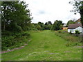
The former Bentley Canal, Willenhall
Part of the route of the former Bentley Canal, which connected the Essington & Wyrley cut (the 'Curly Wyrley') with the Walsall Canal. It started (or ended) at Image with the other end being at Image, and closed in 1961 after more than 100 years of operation. All 10 locks on the route, and the canal itself, have been filled in, and little remains to tell of its existence apart from the occasional trace such as this.
Image: © Richard Law
Taken: 24 Jun 2011
0.17 miles
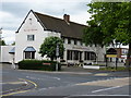
4
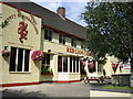
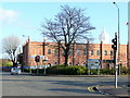
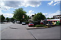
The Red Lion, Willenhall
This public house is on a very busy road.
Image: © Angella Streluk
Taken: 22 Aug 2005
0.19 miles
5
Guru Nanak Gurdwara
Sikh temple viewed from the Walsall Road across Clark's Lane, Willenhall.
Image: © Jonathan Billinger
Taken: 17 Nov 2009
0.19 miles
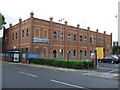
6
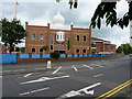
The Guru Nanak Gurdwara Sikh temple in Willenhall
Image: © Richard Law
Taken: 7 Jul 2010
0.19 miles
7
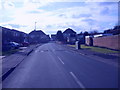
Overdale Drive
A Road off Clarkes Lane, Willenhall.
Image: © Gordon Griffiths
Taken: 5 Mar 2009
0.20 miles
8
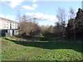
Former Bentley Canal
The Bentley Canal closed in the 1950s. The canal opened in 1843 between Wednesfield and the Anson Branch at Walsall.
Image: © John M
Taken: 2 Feb 2013
0.20 miles
10
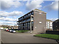
Council Housing - Linden Close
1960s blocks on the Bentley Estate in Walsall.
Image: © John M
Taken: 2 Feb 2013
0.21 miles