IMAGES TAKEN NEAR TO
Jonesfield Crescent, WOLVERHAMPTON, WV1 2LR
Introduction
This page details the photographs taken nearby to Jonesfield Crescent, WV1 2LR by members of the Geograph project.
The Geograph project started in 2005 with the aim of publishing, organising and preserving representative images for every square kilometre of Great Britain, Ireland and the Isle of Man.

There are currently over 7.5m images from over14,400 individuals and you can help contribute to the project by visiting https://www.geograph.org.uk
Image Map
Images are licensed for reuse under creativecommons.org/licenses/by-sa/2.0
Notes
- Clicking on the map will re-center to the selected point.
- The higher the marker number, the further away the image location is from the centre of the postcode.
Image Listing (7 Images Found)
Images are licensed for reuse under creativecommons.org/licenses/by-sa/2.0
Image
Details
Distance
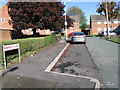
1
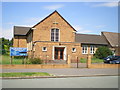
East Park Methodist Church
This sits at the corner of Jonesfield Crescent and Brooklands Parade.
Image: © Richard Law
Taken: 2 Jul 2009
0.07 miles
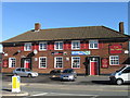
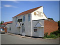
2
The Victoria
A Pub on Dean's Road, Wolverhampton.
Image: © Gordon Griffiths
Taken: 7 Jul 2010
0.17 miles
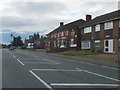
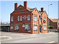
4
The Victoria - public house on Deans Road
I'd call this area the south side of Heath Town in Wolverhampton, but others may consider it to be Moseley.
Image: © Richard Law
Taken: 22 Jul 2009
0.18 miles
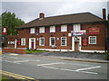
6
The Beehive public house
A free house on Coventry Street, just off the main Willenhall Road.
Image: © Richard Law
Taken: 2 Jul 2009
0.21 miles
7
The British Oak public house
A Banks's pub on the Willenhall Road, east of Wolverhampton.
Image: © Richard Law
Taken: 2 Jul 2009
0.25 miles