IMAGES TAKEN NEAR TO
Knowles Road, WOLVERHAMPTON, WV1 2ET
Introduction
This page details the photographs taken nearby to Knowles Road, WV1 2ET by members of the Geograph project.
The Geograph project started in 2005 with the aim of publishing, organising and preserving representative images for every square kilometre of Great Britain, Ireland and the Isle of Man.

There are currently over 7.5m images from over14,400 individuals and you can help contribute to the project by visiting https://www.geograph.org.uk
Image Map
Images are licensed for reuse under creativecommons.org/licenses/by-sa/2.0
Notes
- Clicking on the map will re-center to the selected point.
- The higher the marker number, the further away the image location is from the centre of the postcode.
Image Listing (184 Images Found)
Images are licensed for reuse under creativecommons.org/licenses/by-sa/2.0
Image
Details
Distance
1
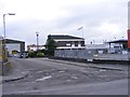
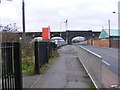
Knowles Road
The view down the Wolverhampton road from Lower Walsall Street.
Image: © Gordon Griffiths
Taken: 1 Dec 2013
0.03 miles
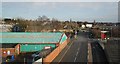
2
Train View
The view from the Wolverhampton Path, a former railway line to the low level station. The train is on the main line to the High Level station, seen in the Monmore Green industrial area of the city.
Image: © Gordon Griffiths
Taken: 7 Feb 2022
0.03 miles
3
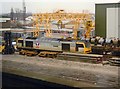
Class 60 at Wolverhampton Steel Terminal, 1998
Class 60 diesel electric locomotive No 60080 at Wolverhampton steel terminal in the winter of 1998
Image: © Rob Newman
Taken: 31 Jan 1998
0.04 miles
4
Lower Walsall Street Train
The view of the Wolverhampton Train heading towards the city station.
Image: © Gordon Griffiths
Taken: 1 Dec 2013
0.04 miles
5
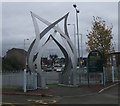
Corser Street Park and Ride
This metal sculpture looks out onto the Willenhall Road. This paint on this side is fairly good but the far side is starting to rust quite badly.
Image: © John M
Taken: 28 Oct 2006
0.05 miles
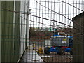
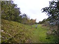
7
Path View
The view down the former railway track from Lower Walsall Street, Wolverhampton.
Image: © Gordon Griffiths
Taken: 1 Dec 2013
0.06 miles
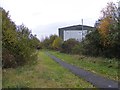
8
Railway Path Scene
The view down the Wolverhampton Path along a former railway line towards Lower Walsall Street in the Monmore Green industrial area of the city.
Image: © Gordon Griffiths
Taken: 1 Dec 2013
0.06 miles
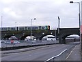
9
Lower Walsall Street Bridge
The view down the Wolverhampton Street towards the railway bridge.
Image: © Gordon Griffiths
Taken: 1 Dec 2013
0.06 miles
10
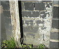
OS benchmark - Wolverhampton, Lower Walsall St railway bridge
An OS cutmark on the buttress of the railway bridge; originally levelled at 142.18m above Ordnance Datum Newlyn.
Image: © Richard Law
Taken: 10 May 2017
0.06 miles