IMAGES TAKEN NEAR TO
Lower Walsall Street, WOLVERHAMPTON, WV1 2ES
Introduction
This page details the photographs taken nearby to Lower Walsall Street, WV1 2ES by members of the Geograph project.
The Geograph project started in 2005 with the aim of publishing, organising and preserving representative images for every square kilometre of Great Britain, Ireland and the Isle of Man.

There are currently over 7.5m images from over14,400 individuals and you can help contribute to the project by visiting https://www.geograph.org.uk
Image Map
Images are licensed for reuse under creativecommons.org/licenses/by-sa/2.0
Notes
- Clicking on the map will re-center to the selected point.
- The higher the marker number, the further away the image location is from the centre of the postcode.
Image Listing (191 Images Found)
Images are licensed for reuse under creativecommons.org/licenses/by-sa/2.0
Image
Details
Distance
1
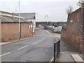
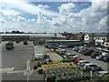
Lower Walsall Street
The view in Horseley Fields, Wolverhampton.
Image: © Gordon Griffiths
Taken: 15 Oct 2013
0.01 miles
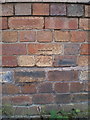
2
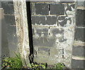
OS benchmark - Wolverhampton, Lower Walsall St railway bridge
An OS cutmark on the buttress of the railway bridge; originally levelled at 142.18m above Ordnance Datum Newlyn.
Image: © Richard Law
Taken: 10 May 2017
0.04 miles
3
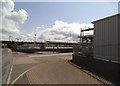
Lower Walsall Street Works
The view of the Works between the Birmingham Canal and the Main Railway line in Wolverhampton.
Image: © Gordon Griffiths
Taken: 6 Aug 2014
0.04 miles
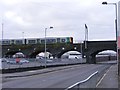
4
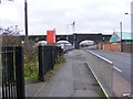
Lower Walsall Street Bridge
The view down the Wolverhampton Street towards the railway bridge.
Image: © Gordon Griffiths
Taken: 1 Dec 2013
0.04 miles
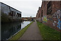
5
Works south of Lower Walsall Street, Wolverhampton
The site is occupied by BOC Gases. The street is partly seen on the left. The Birmingham Canal runs beyond and beside the big shed. The view is from a train to Aberystwyth, held up by some signalling problem south of Wolverhampton.
Image: © Robin Stott
Taken: 25 Jun 2015
0.05 miles
6
Lower Walsall Street Train
The view of the Wolverhampton Train heading towards the city station.
Image: © Gordon Griffiths
Taken: 1 Dec 2013
0.05 miles
7
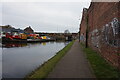
OS benchmark - Wolverhampton, Corporation Wharf
An OS cutmark on the wall of a factory backing onto the canal towpath; originally levelled at 144.957m above Ordnance Datum Newlyn, most likely in 1957.
Image: © Richard Law
Taken: 12 Sep 2016
0.06 miles
10
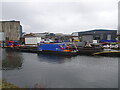
Canal Trust
The view of Minerva Wharf on the Birmingham Canal in Horseley Fields, Wolverhampton.
Image: © Gordon Griffiths
Taken: 10 Feb 2025
0.06 miles