IMAGES TAKEN NEAR TO
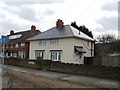
Old Heath Road, WOLVERHAMPTON, WV1 2BF
Introduction
This page details the photographs taken nearby to Old Heath Road, WV1 2BF by members of the Geograph project.
The Geograph project started in 2005 with the aim of publishing, organising and preserving representative images for every square kilometre of Great Britain, Ireland and the Isle of Man.

There are currently over 7.5m images from over14,400 individuals and you can help contribute to the project by visiting https://www.geograph.org.uk
Image Map
Images are licensed for reuse under creativecommons.org/licenses/by-sa/2.0
Notes
- Clicking on the map will re-center to the selected point.
- The higher the marker number, the further away the image location is from the centre of the postcode.
Image Listing (59 Images Found)
Images are licensed for reuse under creativecommons.org/licenses/by-sa/2.0
Image
Details
Distance
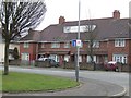
1
Council Housing - Ashbourne Road
Pre-war housing dating from 1937 with the characteristic concrete block walls to frontages also found on the Scotlands and Marsh Lane Estates.
Image: © John M
Taken: 12 Mar 2011
0.05 miles
2
Council Housing - Ashbourne Road
Pre-war development around 1937 with characteristic concrete block wall to frontage. The properties back on to the railway.
Image: © John M
Taken: 12 Mar 2011
0.05 miles
3
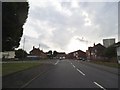
Old Heath Road
The view in Heath Town, Wolverhampton.
Image: © Gordon Griffiths
Taken: 31 Jul 2014
0.06 miles
4
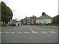
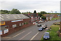
Ashbourne Road
The view of the junction with Old Heath Road in Wolverhampton.
Image: © Gordon Griffiths
Taken: 12 Oct 2014
0.07 miles
5
The Jolly Collier
The Jolly Collier on Old Heath Road.
Image: © Andrew Abbott
Taken: 25 May 2019
0.07 miles
6
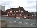
Jolly Collier Public House
The Old Heath Colliery site was redeveloped for Council Housing in the 1920s.
Image: © John M
Taken: 12 Mar 2011
0.08 miles
7
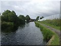
Wyrley & Essington Canal - Approaching Heath Town
Looking towards Wolverhampton.
Image: © John M
Taken: 10 Aug 2008
0.08 miles
8
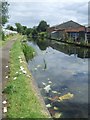
Wyrley & Essington Canal - Heath Town
The Curly Wyrley is only used by very determined boaters. The section between Horseley Fields Junction in Wolverhampton and Sneyd Junction is a home for shopping trolleys and other dumped rubbish. The canal passes through some of the most deprived areas of the city threading behind the 1960s tower blocks.
Image: © John M
Taken: 2 Aug 2009
0.08 miles
9
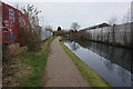
Wyrley & Essington Canal towards Deans Road Bridge
Image: © Ian S
Taken: 16 Dec 2021
0.09 miles
10
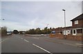
Brickheath Road
The view of the junction with Old Heath Road in Wolverhampton.
Image: © Gordon Griffiths
Taken: 12 Oct 2014
0.09 miles