IMAGES TAKEN NEAR TO
Wesley Road, WILLENHALL, WV12 5QT
Introduction
This page details the photographs taken nearby to Wesley Road, WV12 5QT by members of the Geograph project.
The Geograph project started in 2005 with the aim of publishing, organising and preserving representative images for every square kilometre of Great Britain, Ireland and the Isle of Man.

There are currently over 7.5m images from over14,400 individuals and you can help contribute to the project by visiting https://www.geograph.org.uk
Image Map
Images are licensed for reuse under creativecommons.org/licenses/by-sa/2.0
Notes
- Clicking on the map will re-center to the selected point.
- The higher the marker number, the further away the image location is from the centre of the postcode.
Image Listing (22 Images Found)
Images are licensed for reuse under creativecommons.org/licenses/by-sa/2.0
Image
Details
Distance
2
Coltham Road, Short Heath
Further on after a few interesting bends the A462 is known as Straight Road.
Image: © Richard Webb
Taken: 13 Apr 2016
0.06 miles
3
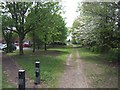
Short Heath Landsale
Following the former colliery railway to the landsale and basin at Short Heath.
A landsale was a site where coal was stockpiled to meet seasonal demand with local sale to coal merchants.
Image: © John M
Taken: 16 Apr 2011
0.08 miles
4
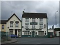
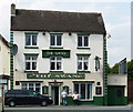
Swan Inn, Short Heath
Traditional pub at the end of Straight Road.
Image: © John M
Taken: 19 May 2007
0.09 miles
5
The Swan - a pub on Bentley Lane, Lane Head area
Image: © Richard Law
Taken: 3 Aug 2011
0.10 miles
6
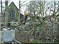
Fallen tree in churchyard
Tree blown over by heavy winds in Holy Trinity church graveyard Shortheath
Image: © Ray Durrant
Taken: 10 Jan 2005
0.10 miles
8
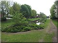
Short Heath Basin
Built in 1906 by the Hollybank Colliery as a colliery wharf and landsale. A mineral railway was constructed directly from the pit in Essington to eliminate the locks on the Wyrley Branch of the Curly Wyrley. The facility remained in use until the closure of the Hilton Main Colliery in the late 1960s.
A landsale was a site where coal was stockpiled to meet seasonal demand with local sale to coal merchants.
Image: © John M
Taken: 16 Apr 2011
0.11 miles
9
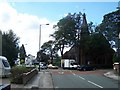
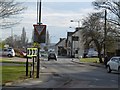
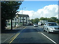
Busy Junction at Short Heath
Short Heath Methodist Church and the Swan pub can be seen in the picture.
Image: © Geoff Pick
Taken: 24 Aug 2006
0.12 miles
10
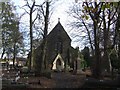
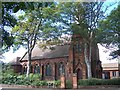
Holy Trinity, Short Heath
The church was consecrated in July 1855. Prior to this services were held in the Jolly Collier.
Image: © John M
Taken: 17 Nov 2007
0.13 miles