IMAGES TAKEN NEAR TO
Andrew Drive, WILLENHALL, WV12 5PJ
Introduction
This page details the photographs taken nearby to Andrew Drive, WV12 5PJ by members of the Geograph project.
The Geograph project started in 2005 with the aim of publishing, organising and preserving representative images for every square kilometre of Great Britain, Ireland and the Isle of Man.

There are currently over 7.5m images from over14,400 individuals and you can help contribute to the project by visiting https://www.geograph.org.uk
Image Map
Images are licensed for reuse under creativecommons.org/licenses/by-sa/2.0
Notes
- Clicking on the map will re-center to the selected point.
- The higher the marker number, the further away the image location is from the centre of the postcode.
Image Listing (34 Images Found)
Images are licensed for reuse under creativecommons.org/licenses/by-sa/2.0
Image
Details
Distance
1
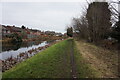
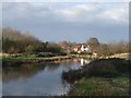
Wyrley & Essington Canal towards Bentley Wharf Bridge
Image: © Ian S
Taken: 16 Dec 2021
0.03 miles
3
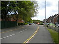
Hunt's Lane, Short Heath
Looking towards Rough Wood from near the junction with Bloxwich Road North.
Image: © Richard Vince
Taken: 29 May 2021
0.07 miles
5
Autumn on the Curly Wyrley
The Wyrley and Essington Canal passes through the Rough Wood Local Nature Reserve near Lane Head.
Image: © John M
Taken: 17 Nov 2007
0.07 miles
6
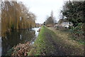
Wyrley & Essington Canal towards Bentley Wharf Bridge
Image: © Ian S
Taken: 16 Dec 2021
0.07 miles
8
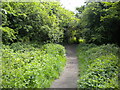
Footpath into Rough Wood, Short Heath (2)
Image: © Richard Vince
Taken: 29 May 2021
0.10 miles
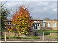
9
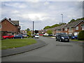
Linden Lane, Short Heath
Seen from the end of Hunt's Lane.
Image: © Richard Vince
Taken: 29 May 2021
0.11 miles
10
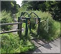
Curious stile at the entrance to the Rough Wood Nature Reserve
Image: © John M
Taken: 28 Jul 2007
0.11 miles