IMAGES TAKEN NEAR TO
Browning Close, WILLENHALL, WV12 5JA
Introduction
This page details the photographs taken nearby to Browning Close, WV12 5JA by members of the Geograph project.
The Geograph project started in 2005 with the aim of publishing, organising and preserving representative images for every square kilometre of Great Britain, Ireland and the Isle of Man.

There are currently over 7.5m images from over14,400 individuals and you can help contribute to the project by visiting https://www.geograph.org.uk
Image Map (Loading...)


Getting Data...Please wait
Leaflet Map data © OpenStreetMap
Images are licensed for reuse under creativecommons.org/licenses/by-sa/2.0
Notes
- Clicking on the map will re-center to the selected point.
- The higher the marker number, the further away the image location is from the centre of the postcode.
Image Listing (15 Images Found)
Images are licensed for reuse under creativecommons.org/licenses/by-sa/2.0
Image
Details
Distance
1
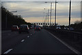
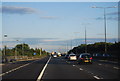
Walsall : The M5 Motorway
Looking along the M5 Motorway as it heads through Walsall.
Image: © Lewis Clarke
Taken: 21 Apr 2016
0.09 miles
2
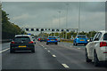
Walsall : M6 Motorway
The M6 Motorway between Junction 10 (Walsall Interchange) and Junction 10A.
Image: © Lewis Clarke
Taken: 22 Sep 2019
0.11 miles
3
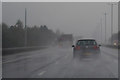
Bloxwich : M6 Motorway
The M6 motorway heading between Junction 10A and Junction 10 (Walsall Interchange).
Image: © Lewis Clarke
Taken: 27 Sep 2019
0.12 miles
4
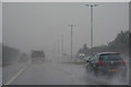
Bloxwich : M6 Motorway
The M6 motorway heading between Junction 10A and Junction 10 (Walsall Interchange).
Image: © Lewis Clarke
Taken: 27 Sep 2019
0.13 miles
6
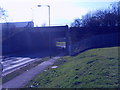
M6 Bridge
The M6 passes over Willenhall Road near Walsall.
Image: © Gordon Griffiths
Taken: 5 Mar 2009
0.19 miles
7
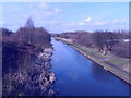
Edwards Bridge View
The Wyrley and Essington Canal viewed from the Willenhall Lane Bridge alongside the M6 motorway at Walsall.
Image: © Gordon Griffiths
Taken: 5 Mar 2009
0.21 miles
8
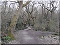
Rough Wood
The go to place for gnarly trees, a long established woodland on small spoil heaps with many marshy depressions. Over the years the path network has improved, not so muddy now.
Image: © Richard Webb
Taken: 13 Apr 2016
0.21 miles
9
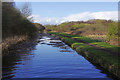
Wyrley & Essington Canal north of Edward's Bridge
Looking towards Sneyd Junction. There is a fair amount of vegetation in the canal here; less obviously there was also a great deal of general rubbish lying in wait to wrap itself around boats' propellers.
Image: © Stephen McKay
Taken: 6 Apr 2016
0.23 miles
10
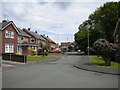
East end of Oaken Drive, Short Heath
Seen from the junction with Linden Lane.
Image: © Richard Vince
Taken: 29 May 2021
0.23 miles