IMAGES TAKEN NEAR TO
Fletcher Road, WILLENHALL, WV12 5ET
Introduction
This page details the photographs taken nearby to Fletcher Road, WV12 5ET by members of the Geograph project.
The Geograph project started in 2005 with the aim of publishing, organising and preserving representative images for every square kilometre of Great Britain, Ireland and the Isle of Man.

There are currently over 7.5m images from over14,400 individuals and you can help contribute to the project by visiting https://www.geograph.org.uk
Image Map
Images are licensed for reuse under creativecommons.org/licenses/by-sa/2.0
Notes
- Clicking on the map will re-center to the selected point.
- The higher the marker number, the further away the image location is from the centre of the postcode.
Image Listing (28 Images Found)
Images are licensed for reuse under creativecommons.org/licenses/by-sa/2.0
Image
Details
Distance
1

Semi-detached bungalows in Fletcher Road
Early 1960s council estate in New Invention.
Image: © John M
Taken: 18 Apr 2009
0.02 miles
2
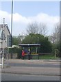
Waiting for the bus in New Invention
Behind the bus shelter the line of the old colliery railway between Sneyd and the canal wharf at Short Heath is still walkable. At this point there was an unbarriered level crossing across the Lichfield Road. The line closed in the late 1960s.
Image: © John M
Taken: 18 Apr 2009
0.09 miles
5
Colliery railway
In 1906 a railway was constructed between Sneyd Colliery and a new landsale and canal basin at Short Heath on the Wyrley and Essington Canal. This closed in the late 1960s with the demise of Hilton Main colliery and opencast working on the Sneyd Colliery site.
Image: © John M
Taken: 18 Apr 2009
0.10 miles
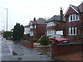
6

New Invention Methodist Church
Built in 1898 (according to the stone in the gable end), the church sits on the Lichfield Road
Image: © Richard Law
Taken: 3 Aug 2011
0.11 miles
7
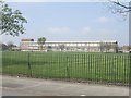
Beacon Primary School
In the heart of a 1960s council estate.
Image: © John M
Taken: 18 Apr 2009
0.11 miles
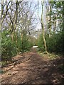
8
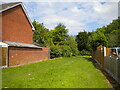
Grassy footpath off Fletcher Road, Allens Rough
Image: © Richard Vince
Taken: 29 May 2021
0.12 miles
9
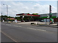
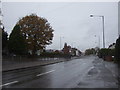
Texaco - New Invention
A petrol station on the A4124 junction with Pooles Lane
Image: © Richard Law
Taken: 3 Aug 2011
0.13 miles
10
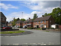
East end of Stretton Road, Allens Rough
Seen from its junction with Heath Road.
Image: © Richard Vince
Taken: 29 May 2021
0.14 miles