IMAGES TAKEN NEAR TO
Cranleigh Close, WILLENHALL, WV12 5DG
Introduction
This page details the photographs taken nearby to Cranleigh Close, WV12 5DG by members of the Geograph project.
The Geograph project started in 2005 with the aim of publishing, organising and preserving representative images for every square kilometre of Great Britain, Ireland and the Isle of Man.

There are currently over 7.5m images from over14,400 individuals and you can help contribute to the project by visiting https://www.geograph.org.uk
Image Map
Images are licensed for reuse under creativecommons.org/licenses/by-sa/2.0
Notes
- Clicking on the map will re-center to the selected point.
- The higher the marker number, the further away the image location is from the centre of the postcode.
Image Listing (6 Images Found)
Images are licensed for reuse under creativecommons.org/licenses/by-sa/2.0
Image
Details
Distance
1
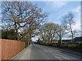
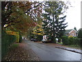
Essington Road
Near the site of a farm called Allen's Rough.
Image: © Richard Webb
Taken: 13 Apr 2016
0.04 miles
2
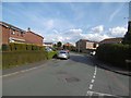
Milestone Way, New Invention
Late 1980s housing development.
Image: © Richard Webb
Taken: 13 Apr 2016
0.15 miles
3
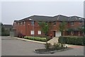
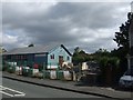
Health Centre on Coppice Farm Estate
Modern health centre serving the Coppice Farm Estate.
Image: © John M
Taken: 16 Sep 2006
0.19 miles
4
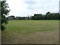
Playing fields off Sneyd Lane
A small open space off Sneyd Lane, surrounded by housing on its western, southern and eastern boundaries.
Image: © Richard Law
Taken: 3 Aug 2011
0.22 miles
6
Allen's Rough Methodist Church Hall
The church has gone and presumably the hall will follow this week.
Image
Image: © John M
Taken: 22 Jun 2008
0.24 miles