IMAGES TAKEN NEAR TO
Eaton Rise, WILLENHALL, WV12 4SH
Introduction
This page details the photographs taken nearby to Eaton Rise, WV12 4SH by members of the Geograph project.
The Geograph project started in 2005 with the aim of publishing, organising and preserving representative images for every square kilometre of Great Britain, Ireland and the Isle of Man.

There are currently over 7.5m images from over14,400 individuals and you can help contribute to the project by visiting https://www.geograph.org.uk
Image Map
Images are licensed for reuse under creativecommons.org/licenses/by-sa/2.0
Notes
- Clicking on the map will re-center to the selected point.
- The higher the marker number, the further away the image location is from the centre of the postcode.
Image Listing (31 Images Found)
Images are licensed for reuse under creativecommons.org/licenses/by-sa/2.0
Image
Details
Distance
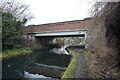
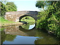
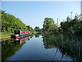
1
Wyrley & Essington Canal at Pool Hayes Bridge
Image: © Ian S
Taken: 16 Dec 2021
0.08 miles
2
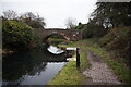
Wyrley & Essington Canal at Pool Hayes Bridge
Image: © Ian S
Taken: 16 Dec 2021
0.08 miles
3
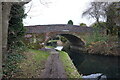
Wyrley & Essington Canal at Pool Hayes Bridge
Image: © Ian S
Taken: 16 Dec 2021
0.08 miles
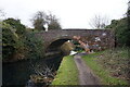
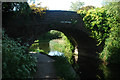
4
Pool Hayes Bridge, from the east
An accommodation bridge on the Wyrley & Essington Canal.
Image: © Christine Johnstone
Taken: 7 May 2018
0.08 miles
6
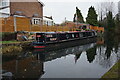
Canal boat Senior Moment, Wyrley & Essington Canal
Image: © Ian S
Taken: 16 Dec 2021
0.10 miles
7
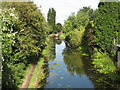
View from Lucknow Road Bridge
Wyrley & Essington Canal.
Image: © Adrian Rothery
Taken: 14 Aug 2008
0.10 miles
8
Narrowboat moored on the Wyrley & Essington Canal
North of Pool Hayes Bridge.
Image: © Christine Johnstone
Taken: 7 May 2018
0.12 miles
9
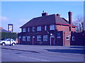
The Jolly Collier
The Pub stands in Lucknow Road.
Image: © Gordon Griffiths
Taken: 5 Mar 2009
0.13 miles