IMAGES TAKEN NEAR TO
Mere Close, WILLENHALL, WV12 4PT
Introduction
This page details the photographs taken nearby to Mere Close, WV12 4PT by members of the Geograph project.
The Geograph project started in 2005 with the aim of publishing, organising and preserving representative images for every square kilometre of Great Britain, Ireland and the Isle of Man.

There are currently over 7.5m images from over14,400 individuals and you can help contribute to the project by visiting https://www.geograph.org.uk
Image Map
Images are licensed for reuse under creativecommons.org/licenses/by-sa/2.0
Notes
- Clicking on the map will re-center to the selected point.
- The higher the marker number, the further away the image location is from the centre of the postcode.
Image Listing (5 Images Found)
Images are licensed for reuse under creativecommons.org/licenses/by-sa/2.0
Image
Details
Distance
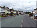
1
Broad Lane South, Wednesfield
Heading north east.
Image: © JThomas
Taken: 5 Oct 2013
0.16 miles
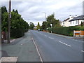
2
Stubby Lane, Wednesfield
A bus stop very close to the junction between Broad Lane South and Stubby Lane
Image: © Richard Law
Taken: 29 Jul 2010
0.18 miles
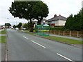
4
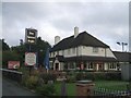
Spreadeagle PH
This public house is on Broad Lane South in a residential area.
Image: © John M
Taken: 30 Sep 2006
0.20 miles