IMAGES TAKEN NEAR TO
Malvern Close, WILLENHALL, WV12 4NS
Introduction
This page details the photographs taken nearby to Malvern Close, WV12 4NS by members of the Geograph project.
The Geograph project started in 2005 with the aim of publishing, organising and preserving representative images for every square kilometre of Great Britain, Ireland and the Isle of Man.

There are currently over 7.5m images from over14,400 individuals and you can help contribute to the project by visiting https://www.geograph.org.uk
Image Map
Images are licensed for reuse under creativecommons.org/licenses/by-sa/2.0
Notes
- Clicking on the map will re-center to the selected point.
- The higher the marker number, the further away the image location is from the centre of the postcode.
Image Listing (6 Images Found)
Images are licensed for reuse under creativecommons.org/licenses/by-sa/2.0
Image
Details
Distance
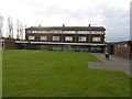
1

New houses, Ashmore Lake
Off Spring Lane, Willenhall.
Image: © Richard Webb
Taken: 13 Apr 2016
0.15 miles
2
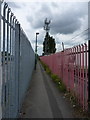
Telecoms mast and footpath in Spring Bank
Image: © Richard Law
Taken: 24 Jun 2011
0.21 miles
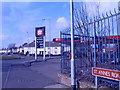
4
Shops, Lucknow Road
Post war housing development, Willenhall.
Image: © Richard Webb
Taken: 13 Apr 2016
0.24 miles
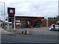
5
Monmer Lane Garage
The Garage stands on the corner of Monmer Lane and St Anne's Road, Willenhall.
Image: © Gordon Griffiths
Taken: 5 Mar 2009
0.24 miles
6
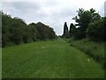
Bentley Canal
The line of the canal which fell into disrepair in the 1960s.
Image: © John M
Taken: 7 Jun 2008
0.25 miles