IMAGES TAKEN NEAR TO
High Road, WILLENHALL, WV12 4JQ
Introduction
This page details the photographs taken nearby to High Road, WV12 4JQ by members of the Geograph project.
The Geograph project started in 2005 with the aim of publishing, organising and preserving representative images for every square kilometre of Great Britain, Ireland and the Isle of Man.

There are currently over 7.5m images from over14,400 individuals and you can help contribute to the project by visiting https://www.geograph.org.uk
Image Map
Images are licensed for reuse under creativecommons.org/licenses/by-sa/2.0
Notes
- Clicking on the map will re-center to the selected point.
- The higher the marker number, the further away the image location is from the centre of the postcode.
Image Listing (38 Images Found)
Images are licensed for reuse under creativecommons.org/licenses/by-sa/2.0
Image
Details
Distance
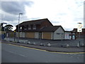
4
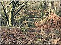
All gone!
The site of the former Lane Heath Methodist Church - all that's left is a rather sad wooden sign just inside the chain-link fence, to give away the identity of the church that formerly occupied the site.
Image: © Richard Law
Taken: 3 Aug 2011
0.05 miles
5
Old Boundary Marker beside the Huddersfield Canal near Millbrook
Parish Boundary Marker on the west side of the Huddersfield Narrow Canal near Millbrook. On the former boundary of Stalybridge, Cheshire and Ashton-under-Lyne, Lancashire but now entirely in an unparished area of Tameside Metropolitan District. S is assumed to indicate Stalybridge.
Milestone Society National ID: CH_STAAUL01pb
Image: © D Garside
Taken: 25 Feb 2022
0.06 miles
7
Canada geese on Monarch's Way, off Greadier Street
Aka the towpath of the Wyrley & Essington Canal.
Image: © Christine Johnstone
Taken: 7 May 2018
0.12 miles
9
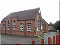
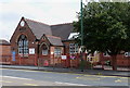
Lane Head Nursery School
The former Short Heath Board School built in 1880.
Image: © John M
Taken: 24 Jun 2007
0.14 miles
10
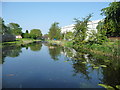
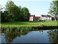
The Wyrley & Essington Canal, looking west at Lane Head
Lilies grow in the clear water. The house is on Greadier Street.
Image: © Christine Johnstone
Taken: 7 May 2018
0.14 miles