IMAGES TAKEN NEAR TO
Whitewood Glade, WILLENHALL, WV12 4BN
Introduction
This page details the photographs taken nearby to Whitewood Glade, WV12 4BN by members of the Geograph project.
The Geograph project started in 2005 with the aim of publishing, organising and preserving representative images for every square kilometre of Great Britain, Ireland and the Isle of Man.

There are currently over 7.5m images from over14,400 individuals and you can help contribute to the project by visiting https://www.geograph.org.uk
Image Map
Images are licensed for reuse under creativecommons.org/licenses/by-sa/2.0
Notes
- Clicking on the map will re-center to the selected point.
- The higher the marker number, the further away the image location is from the centre of the postcode.
Image Listing (10 Images Found)
Images are licensed for reuse under creativecommons.org/licenses/by-sa/2.0
Image
Details
Distance
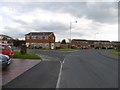
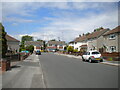
2

Poplar Avenue, Bentley
Approaching the junction with Attlee Road.
Image: © Richard Vince
Taken: 29 May 2021
0.19 miles
3
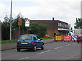
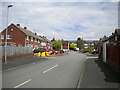
Shops and road works on Stroud Avenue, Willenhall
Image: © Angella Streluk
Taken: 22 Aug 2005
0.19 miles
4
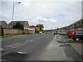
Southern part of Stroud Avenue, Lodge Farm
The estate's main distributor road, which forms a complete circuit. Seen from close to the junction with Granbourne Road.
Image: © Richard Vince
Taken: 29 May 2021
0.20 miles
5
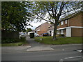
Footpath to Calstock Road, Lodge Farm
Off Stroud Avenue.
Image: © Richard Vince
Taken: 29 May 2021
0.21 miles
6
North end of Attlee Road, Bentley
Approaching Poplar Avenue.
Image: © Richard Vince
Taken: 29 May 2021
0.22 miles
7
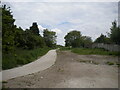
Footpath off Granbourne Road, Bentley
Not shown as a public right of way on OS maps, this path reuses part of the trackbed of the former Midland Railway line between Walsall and Wolverhampton, which was closed as a through route in 1964 when it was severed by the construction of the M6 about half a mile east of here.
Image: © Richard Vince
Taken: 29 May 2021
0.22 miles
8
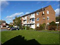
Almond Avenue, Bentley
Block of flats at the end of Almond Avenue. They're solar-panelled right up.
Image: © Richard Law
Taken: 2 Nov 2012
0.22 miles
9
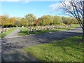
Willenhall Lawn Cemetery
The NE corner of this extensive cemetery.
Image: © Richard Law
Taken: 2 Nov 2012
0.22 miles
10
Almond Avenue, Bentley
A cul de sac off Attlee Road.
Image: © Richard Vince
Taken: 29 May 2021
0.23 miles